

-
 Redaction
El Niño 2026: How strong will this giant get?
El Niño has officially arrived. NOAA warns of a potentially historic event - here's what it means for weather, food security and your community.
The arrival of a Pacific giant
The air above the tropical Pacific has a specific weight when the seasons shift - a humid stillness that precedes change. On June 11, 2026, the National Oceanic and Atmospheric Administration (NOAA) confirmed what sensors, buoys, and satellite arrays have been whispering for months: El Niño has officially arrived. It is not merely a seasonal guest. It is a thermal giant waking from a multi-year slumber, and its footprint will be felt on every continent before it is done.
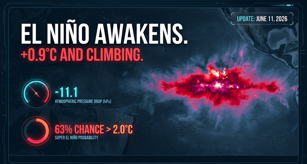
The declaration follows sustained observation in the critical Niño 3.4 region of the equatorial Pacific, where sea surface temperatures have climbed well past the required 0.5°C anomaly threshold - and kept climbing. The International Research Institute for Climate and Society (IRI) at Columbia University reported weekly readings of +0.9°C in the Niño 3.4 region as early as mid-May, alongside a sharp collapse in the Southern Oscillation Index to -11.1, a clear atmospheric signature of a disrupted Walker Circulation.
For those living along the coastlines of Peru or the islands of Indonesia, the shift is already palpable. The cooling influence of La Niña, which dominated the previous three years, has dissipated entirely. In its place, a massive pool of warm water is migrating eastward across the equator. This movement represents a redistribution of energy so vast it will fundamentally alter the planetary heat engine - influencing everything from the strength of Atlantic hurricanes to the price of a bag of rice in Jakarta.
How strong will this El Niño get?
Meteorologists at NOAA's Climate Prediction Center are watching this event intensify at a rate that is drawing comparisons to the most destructive episodes in the historical record. Current probabilistic forecasts tell a striking story:
- A 63% chance of sea surface temperatures in the monitored Pacific region exceeding 2.0°C above average - NOAA's threshold for a "very strong" event.
- An overall probability of 84% that the event reaches at least moderate-to-strong strength.
- A 56% chance of a "strong" classification before the year is out.
- ECMWF ensemble models placing the probability of a full "super El Niño" at 100% - the highest confidence level any major centre has assigned to such an outcome.
"One of the most rapid transitions that I've seen," a NOAA forecaster told Live Science, describing the speed at which Pacific Ocean conditions have shifted.
If these projections hold, we may be looking at a thermal anomaly that rivals - or even surpasses - the historic events of 1997-1998 and 2015-2016. Some models are flagging the possibility of Ocean Niño Index values crossing 3°C, a level reached only once before in modern records, in January 1878. In those prior years, global ecosystems were pushed to their limits. The crucial difference in 2026 is that we are starting from a dramatically higher baseline - one shaped by decades of anthropogenic climate change that has already warmed the planet's average surface temperature by roughly 1.1°C since the industrial era began.
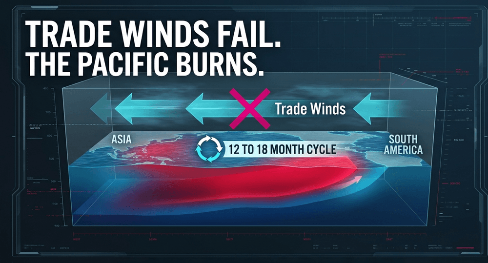
The mechanics of El Niño are rooted in a delicate conversation between the ocean and the atmosphere. Normally, trade winds blow from east to west, pushing warm surface water toward Asia and allowing cooler, nutrient-rich water to well up from the depths along the South American coast. When those winds weaken or reverse, the warm water sloshes back east. This creates a self-reinforcing feedback loop - the warm water heats the air above it, which further disrupts the winds, locking the system into a cycle of warming that can persist for 12 to 18 months.
The blob growing alongside it
Something else is unfolding in the North Pacific that climate scientists are watching with equal unease. Since late 2025, an exceptionally large marine heatwave has been building across the northeast Pacific - a warming event stretching roughly 9,000 miles, comparable in scale to the notorious "Blob" of 2013-2015 that devastated fisheries from Alaska to California. At its peak, this new heatwave (designated NEP25A) covered approximately 10 million square kilometres, setting a record for the largest marine heatwave in that region since satellite monitoring began in 1982.
These two anomalies - the forming El Niño and the sprawling North Pacific marine heatwave - are now evolving together. The warmer waters in the north are weakening the trade winds at the equator, which may itself be helping to initiate El Niño conditions. And because equatorial warming in turn affects the North Pacific, there is a real possibility of a feedback loop: each system amplifying the duration and intensity of the other.
During the 2014 Blob event, the overlap with a powerful El Niño led to widespread toxic algae blooms, catastrophic seabird die-offs, and collapsed fisheries along North America's Pacific coast. Scientists watching the 2026 configuration are acutely aware of that precedent. The combination is not just two problems in parallel - it may be a system that makes each problem worse.
What El Niño means for global weather patterns
The consequences of this shift are never localized. They ripple outward, reshaping precipitation patterns, monsoon seasons, and drought cycles across the entire planet.
In North America, a strong El Niño typically pushes the Pacific jet stream into a more southerly position. The practical result is wetter, cooler winters for the southern tier of the United States - from California to the Carolinas - and warmer, drier conditions across the northern US and Canada. While this may offer temporary drought relief to parts of the American West, it also substantially elevates the risk of catastrophic flooding, mudslides, and infrastructure damage in communities that sit in the path of an enhanced storm track.
In South and Southeast Asia, the picture is starker. El Niño tends to suppress the Indian monsoon - the system responsible for roughly 70% of India's annual rainfall, and sometimes called the nation's "real finance minister" given its outsized role in agricultural GDP. India's meteorological department has already revised its 2026 monsoon forecast downward to 90% of the long-period average - a level classified as "below normal" - raising fears of deficient rainfall across rain-fed farming regions through July and August, the two most critical months for the country's agricultural output.
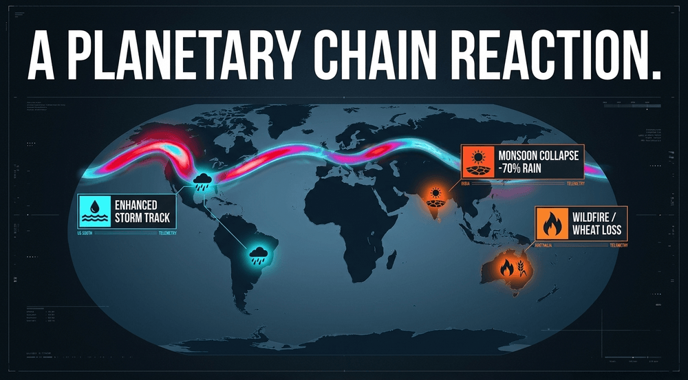
Australia faces a familiar threat: prolonged dryness that elevates wildfire risk across the east and southeast of the continent, and reduces wheat production during the critical spring growing window.
In southern Brazil and Argentina, by contrast, El Niño often brings above-average rainfall, which can actually benefit soybean and corn yields - though this benefit is unevenly distributed and can arrive at the wrong time of the growing season.
One partial consolation sits in the Atlantic. Historically, El Niño increases vertical wind shear over the Atlantic Ocean, which disrupts hurricane formation. NOAA's 2026 Atlantic Hurricane Season Outlook, in fact, projects a 55% probability of a below-average Atlantic hurricane season - a rare piece of meteorological good news in an otherwise turbulent picture. However, record-warm Atlantic sea surface temperatures driven by background global warming are expected to counteract this dampening effect to some degree, making the season substantially more unpredictable than any straightforward historical comparison would suggest. The central and eastern Pacific, meanwhile, may see more hurricane activity - an elevated threat for Hawaii and the southwestern US coastline that often goes underappreciated.
The ecological stakes: coral reefs and fisheries under pressure
Perhaps no ecosystem faces a more immediate reckoning than the world's coral reefs. Higher sea surface temperatures cause corals to expel the symbiotic algae living in their tissues - a process called bleaching. Without those algae, which supply most of the coral's nutrition, the reef enters a race against starvation and disease. Corals can recover if temperatures drop quickly enough. If they do not, they die.
The Great Barrier Reef has already endured seven mass bleaching events since 1998. The most recent, confirmed in March 2024, was particularly alarming because it unfolded during La Niña conditions - a period when cooler, wetter weather typically offers corals some protection. That event caused moderate or severe bleaching across 60% of the 1,036 reefs surveyed from the air. With coral cover still struggling to recover, scientists are gravely concerned about the additional thermal stress this El Niño will impose.
"Coral bleaching disrupts the entire reef ecosystem, causing a loss of critical habitats that serve as important feeding and nesting grounds for thousands of marine species." - Great Barrier Reef Foundation
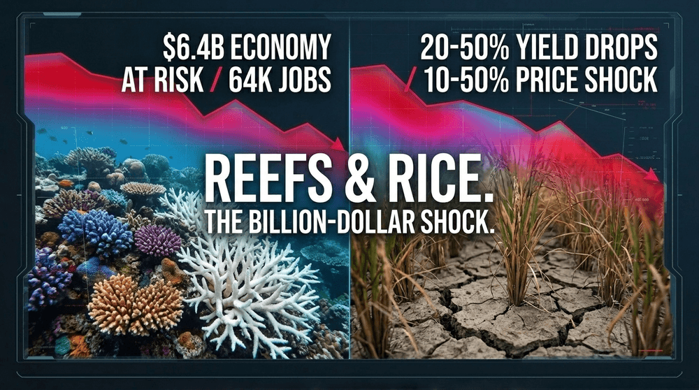
The Great Barrier Reef generates an estimated $6.4 billion annually for Australia's economy and supports around 64,000 jobs in tourism - a figure that falls sharply in the aftermath of bleaching events. Beyond Australia, over 500 million people globally depend on reef fisheries for food security and income, a figure that underscores the human stakes embedded in this oceanographic process.
The open ocean faces its own crisis. Warming surface waters suppress the upwelling of cold, nutrient-rich water that sustains the world's most productive fisheries - particularly off the coast of South America. Fish populations migrate or collapse, sending ripple effects through the marine food web and the coastal communities that depend on it. The 2013-2015 Blob's overlap with the 2015-2016 El Niño offers a grim reference point: widespread harmful algae blooms, significant seabird die-offs, and fisheries disruptions that took years to stabilise. Scientists fear a comparable, or worse, cascade in the months ahead.
The 1.5°C threshold: how El Niño accelerates a moment of reckoning
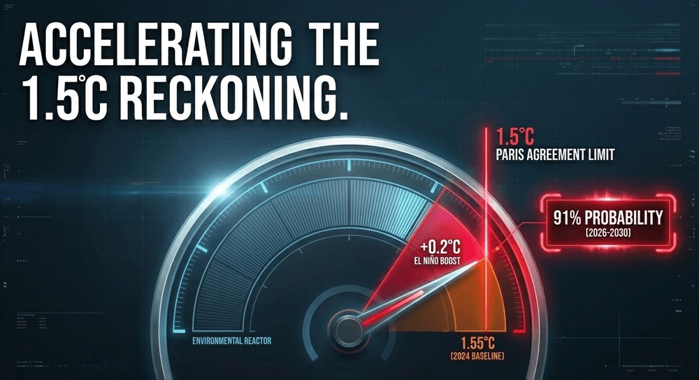
What makes this particular El Niño uniquely alarming is the context in which it arrives. The World Meteorological Organization (WMO) now places a 91% probability on at least one year between 2026 and 2030 temporarily exceeding 1.5°C of warming above pre-industrial levels - the guardrail enshrined in the 2015 Paris Agreement. There is also a 75% chance that the five-year average warming across the entire 2026-2030 period will exceed that same threshold. Separately, an 86% probability has been assigned to at least one year in this window breaking the 2024 record for the hottest year ever observed.
El Niño typically adds roughly 0.2°C to the global surface temperature in the year or two following its peak. When that boost is applied to a baseline that already reached 1.55°C in 2024 - the hottest year on record and the first to breach the 1.5°C limit - the mathematics become sobering.
"There is an El Niño predicted for the end of 2026, which increases the chances of the following year, 2027, being the next record-breaking year." - Dr Leon Hermanson, lead author of the WMO Global Annual-to-Decadal Climate Update
It bears emphasising that a single warm year does not constitute a Paris Agreement failure - the accord's thresholds refer to warming sustained over 20-year averages. But each temporary exceedance is a vivid preview of conditions that, if left unaddressed, will eventually become permanent. And as the atmosphere holds more moisture with each additional fraction of a degree, the rainfall events that do arrive become more violent, while the dry spells in regions like Australia, the Mediterranean, and southern Africa grow longer and more severe.
Global food security and the economics of disruption
The economic consequences of a strong El Niño are measured in the billions, and agriculture is the first sector to feel the strain. Analysts and food security researchers are now sounding alarms about the potential for simultaneous commodity shocks across multiple staple crops - a scenario that differs dangerously from historical precedent, where price shocks tended to arrive one at a time.
Research published in Nature Food warns that the 2026 El Niño threatens global food supply chains through simultaneous production losses across multiple breadbasket regions - reducing rice output in Southeast Asia, wheat in Australia, maize in South America, and pulses in India all at once. Overall global food prices could rise by 5 to 8%, potentially pushing an additional 15 to 20 million people into food insecurity, particularly in developing countries.
Commodities particularly at risk include:
- Rice - with India, Thailand, and Vietnam all exposed to monsoon disruption and dry-season output losses; the World Bank cautions that South Asian rice output could fall by 20 to 50% under a strong El Niño scenario
- Palm oil - threatened by drought in Indonesia and Malaysia
- Coffee and cocoa - linked to tropical climate patterns across West Africa and Central America
- Soybeans and wheat - facing uncertainty across the Southern Hemisphere planting calendar
Forecasters warn of commodity price shocks of 10-50% across core agricultural staples, with the most exposed crops potentially seeing surges far beyond that. In India specifically, food inflation is projected to rise 8-12% from its baseline, hitting wheat, rice, pulses, and vegetables hardest - compounding existing rural economic pressures and raising the spectre of stagflation in an economy already navigating a weakened monsoon outlook.
These are not abstract numbers. They arrive at the household level in the form of unaffordable school meals, disrupted livelihoods, and worsening malnutrition among populations that were already stretched thin before this event began.
What communities and governments can do right now
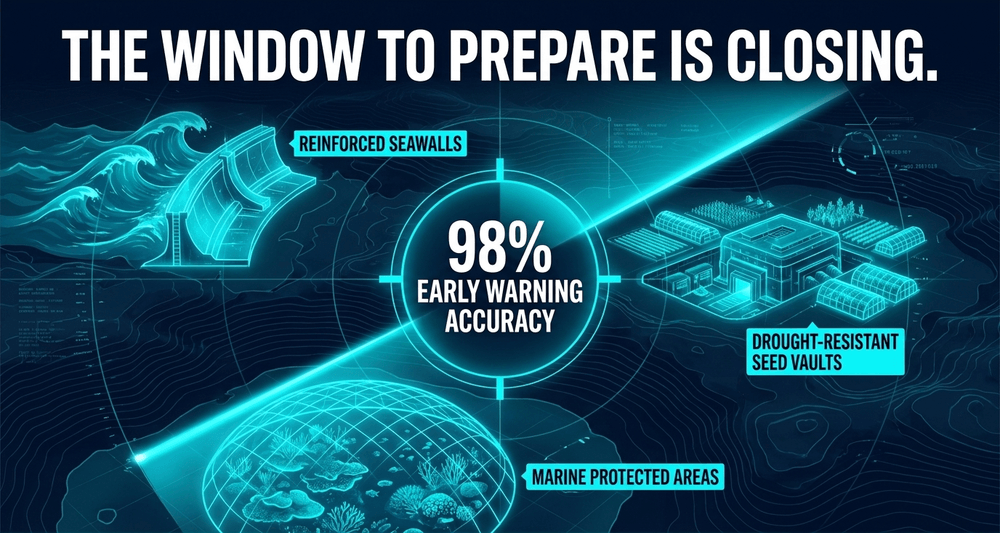
This is not a moment for passive observation. NOAA's formal declaration is both a scientific milestone and a call to action - a signal that the window for preparation is open, even if it will not remain so indefinitely.
Key priorities for governments, emergency planners, and communities include:
- Flood defence reinforcement in coastal cities and low-lying urban areas exposed to an enhanced storm track
- Water reservoir and drought management protocols in regions historically prone to drying under El Niño
- Agricultural contingency planning, including early access to drought-resistant seed varieties and flexible insurance mechanisms for smallholder farmers
- Marine protected area enforcement to give coral ecosystems the best possible chance of surviving thermal stress
- Social safety net strengthening for fishing communities, agricultural workers, and others whose incomes are directly tied to weather stability
The tools available to us today are vastly more powerful than those of even a decade ago. Advanced satellite monitoring systems track sea surface temperatures and ocean heat content in near-real time. Ensemble climate models now provide probabilistic forecasts months in advance, giving emergency planners a meaningful head start. The IRI ENSO forecast plume assigned a 98% probability to El Niño conditions during May-July 2026 months before the formal NOAA declaration - an extraordinary degree of foresight that earlier generations of scientists could only have dreamed of. The WMO, for its part, has issued a dedicated "Prepare for El Niño" briefing to governments and humanitarian agencies, urging immediate review of agricultural, water, health, and disaster risk systems.
Looking ahead: adaptation as the defining task
We are no longer passive observers of these cycles. The declaration by NOAA is, at its core, an act of scientific transparency - a community of dedicated researchers sharing what they know, as clearly and as early as possible, so that the rest of us can act on it.
The coming months will test our infrastructure, our economies, and our ability to cooperate across borders and political divides. But they also offer a genuine chance to demonstrate that humanity has grown wiser about the planet we inhabit. Every early warning heeded, every flood barrier reinforced, every farming community supported through a difficult season - these are not small acts. They are the cumulative architecture of resilience.
What separates 2026 from 1997 is not just the physics of the ocean warming. It is the existence of the warning systems, the institutional memory, and the scientific clarity to understand what is coming and why. The question that remains is whether that knowledge will be translated into action quickly enough - and equitably enough - to protect those most exposed.
The Pacific has spoken. The question now is whether we are listening.
Share now









Key takeaways
- On June 11, 2026, NOAA officially declared El Niño, issuing an El Niño Advisory confirming the warm phase of the El Niño-Southern Oscillation (ENSO) has developed in the tropical Pacific - the first El Niño after three consecutive years of La Niña dominance.
- NOAA forecasters place a 63% probability on sea surface temperatures exceeding 2.0°C above the historical average in the Niño 3.4 region - the threshold for a "very strong" El Niño - with an 84% chance of at least a moderate-to-strong event.
- Weekly sea surface temperature anomalies in the Niño 3.4 region reached +0.9°C as early as mid-May 2026, with the Southern Oscillation Index collapsing to -11.1 - a clear atmospheric signature of a breaking Walker Circulation.
- ECMWF models project sea surface temperature anomalies potentially reaching +3°C by December 2026, with some scenarios exceeding +4°C - which would make this the strongest El Niño in modern instrumental records, possibly rivalling the catastrophic event of 1877-1878.
- A 9,000-mile marine heatwave (NEP25A) has been building in the North Pacific since late 2025, reaching approximately 10 million km² - the largest northeast Pacific marine heatwave since satellite monitoring began in 1982 - and is evolving alongside El Niño, with each system potentially amplifying the other.
- The World Meteorological Organization (WMO) puts a 91% probability on at least one year between 2026 and 2030 temporarily exceeding the 1.5°C warming limit above pre-industrial levels, and an 86% probability that one of those years will break the 2024 record as the hottest ever observed.
- El Niño typically adds roughly 0.2°C to global surface temperatures; applied to the 1.55°C anomaly already recorded in 2024, the combined effect makes 2027 the most likely candidate for the next record-breaking year, according to WMO lead author Dr Leon Hermanson.
- The Great Barrier Reef faces renewed mass bleaching risk: coral cover is still recovering from the March 2024 bleaching event, which caused moderate or severe bleaching across 60% of the 1,036 reefs surveyed - and that event unfolded during La Niña conditions, underscoring how little thermal buffer remains.
- Over 500 million people globally depend on reef fisheries for food security and income; the World Bank cautions that rice output in South Asia, Southern Africa, and parts of East Asia could fall by 20 to 50% under a strong El Niño scenario, with broader commodity price shocks of 10-50% expected across staple crops.
- Advanced forecasting allowed the IRI at Columbia University to assign a 98% probability to El Niño conditions during May-July 2026 months before NOAA's formal declaration - illustrating the dramatic improvement in modern climate prediction that now gives governments and communities a genuine head start on preparation.
Sources
- NOAA https://www.noaa.gov/news-release/el-nino-forms-expected-to-strengthen-say-noaa-forecasters
- World Meteorological Organization (WMO) https://wmo.int/news/media-centre/new-report-suggests-more-global-temperature-records-ahead
- Bulletin of the Atomic Scientists https://thebulletin.org/2026/05/how-a-monster-ocean-heatwave-could-fuel-a-super-el-nino/
- Great Barrier Reef Foundation https://www.barrierreef.org/news/explainers/el-nino-what-does-it-mean-for-the-great-barrier-reef
- UN News https://news.un.org/en/story/2026/05/1167596
- Published 2026-06-11 22:34
- Modified 2026-06-11 22:42

-
Redaction