

-
 PRO
PRO -
 Redaction
Digital deforestation: LiDAR and the ancient world
What is digital deforestation in archaeology? How LiDAR maps hidden ruins beneath jungle canopies - and the ethical challenges that come with every discovery.
The air above the Maya Biosphere Reserve in Guatemala is often a thick, humid haze - a green curtain that has guarded the secrets of the ancient world for centuries. For generations, archaeologists hacked through this jungle with machetes, mapping single mounds and plazas over months of grueling fieldwork. Today, that paradigm has shifted entirely. The emergence of LiDAR (Light Detection and Ranging) has introduced a process known as digital deforestation - a technical breakthrough that allows researchers to peel back the forest canopy without disturbing a single leaf.
This technology does not merely assist archaeology; it has fundamentally rewritten the scale at which we understand human history.
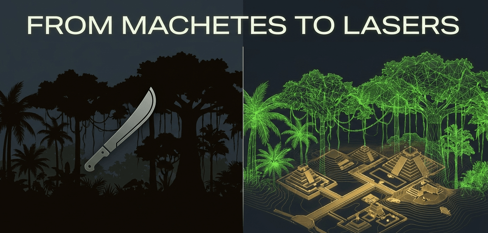
Standing on the ground in a dense tropical rainforest, your field of vision is limited to a few meters. You might be standing next to a pyramid and mistake it for a natural hill. LiDAR changes this by providing an aerial perspective that is both vast and impossibly precise. By emitting millions of laser pulses from an aircraft, the technology captures the subtle undulations of the earth, revealing the ghosts of ancient highways, reservoirs, and agricultural terraces that have been swallowed by the wild. This is not just a new tool - it is a lens that provides a form of X-ray vision into the past, offering a clarity that traditional surveying could never achieve.

The physics of the laser pulse
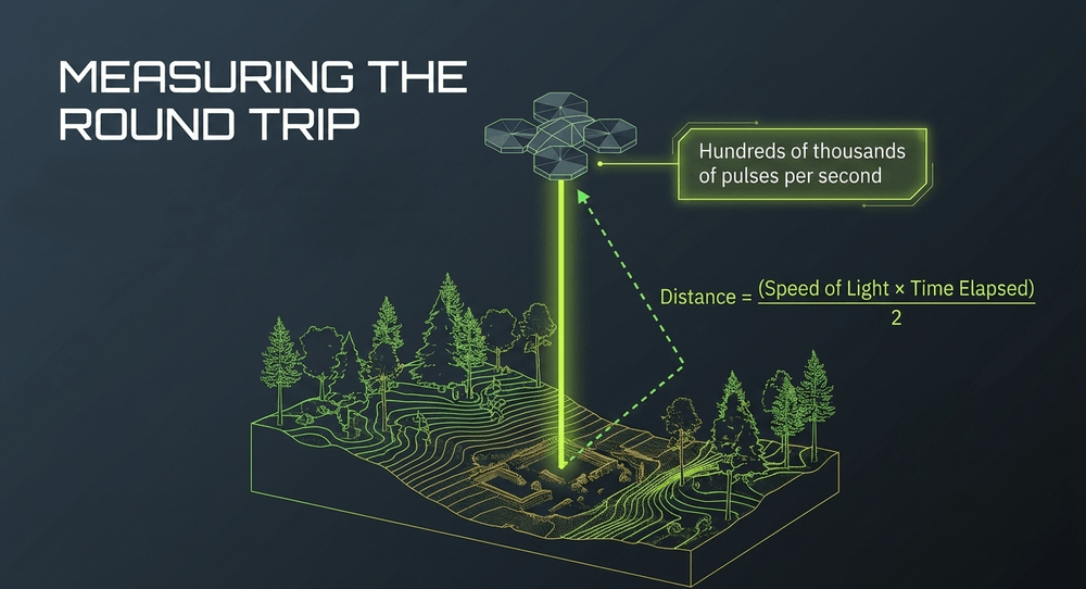
To understand the power of LiDAR, you have to look at the physics of the laser pulse itself. These systems, mounted on drones or light aircraft, emit pulses at a rate of several hundred thousand per second. Each pulse travels to the surface and bounces back. The distance is then calculated using the formula: Distance = (Speed of Light × Time Elapsed) / 2. Because light travels at a constant speed, the return time provides a measurement of the distance between the sensor and the target with millimetric precision. The division by two accounts for the round trip the pulse makes - down to the surface and back to the sensor.
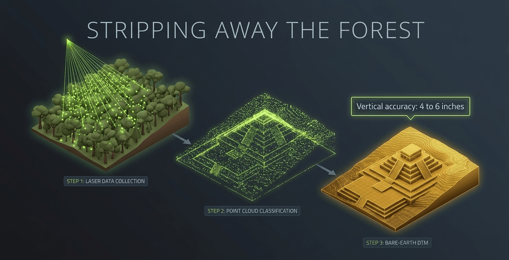
In a forested environment, some of these pulses hit the top of the trees, others hit branches, and a small percentage find gaps in the leaves to strike the forest floor. This results in a dense point cloud - a 3D scatter plot of every surface the laser touched. The magic of digital deforestation lies in the post-processing algorithms. Data analysts can classify these points, stripping away everything that is not the ground. What remains is a Digital Terrain Model (DTM): a bare-earth representation that looks as though the forest has been surgically removed, leaving behind the raw topography of a human-modified landscape.
Contemporary systems offer vertical accuracy within 4 to 6 inches (roughly 10-15 cm), sensitive enough to detect features as small as 12 inches across. This means that a shallow drainage ditch or a low-lying house platform, eroded by a thousand years of rain, suddenly becomes visible in the digital record. For the first time, we are seeing the infrastructure of ancient life - not just the grand temples, but the humble farms and roads that supported them.
Why LiDAR is dramatically faster than traditional surveys
The primary advantage of LiDAR is its sheer speed. In traditional archaeology, mapping a 13-square-kilometer area would take a dedicated team years of seasonal fieldwork. Today, that same area can be mapped in approximately 45 minutes of flight time. Modern systems can cover 50 square miles in a single day.
This efficiency has allowed for the survey of massive tracts of land that were previously considered too remote or too dense for investigation. Data from an ASPRS (American Society for Photogrammetry and Remote Sensing) study indicated that LiDAR surveys provided time savings of up to 40% while improving spatial accuracy by 2 to 5 times compared to conventional surveying methods.
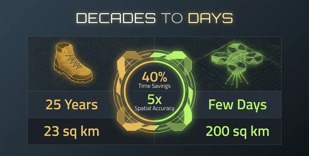
This shift from local mapping to landscape-scale mapping has allowed archaeologists to move away from studying sites in isolation. We are no longer looking at a single city - we are looking at entire regional networks. This macro-level view is essential for understanding how ancient societies managed water, defense, and food production on a continental scale. At Caracol in Belize, for example, it took archaeologists roughly 25 years on foot to survey approximately 23 square kilometers of the site. A LiDAR survey then covered 200 square kilometers in just a few days, effectively transforming the understood scale of the entire city in a single mission.
The Maya discoveries that changed everything
The most celebrated application of this technology in the Maya lowlands revealed more than 61,000 previously hidden structures across over 2,144 square kilometers of the Maya Biosphere Reserve in northern Guatemala. The PACUNAM LiDAR Initiative, published in the journal Science, transformed understanding of Maya civilization - suggesting that the population was likely millions higher than previously estimated. The scans revealed fortresses, complex irrigation systems, and wide highways known as sacbeob that interconnected distant urban centers, indicating a level of political and economic integration that was hitherto unknown.
"LiDAR has shown that the Maya lowlands were a densely occupied landscape, comparable in scale and complexity to the ancient civilizations of China or Southeast Asia." - Marcello Canuto et al., Science, 2018
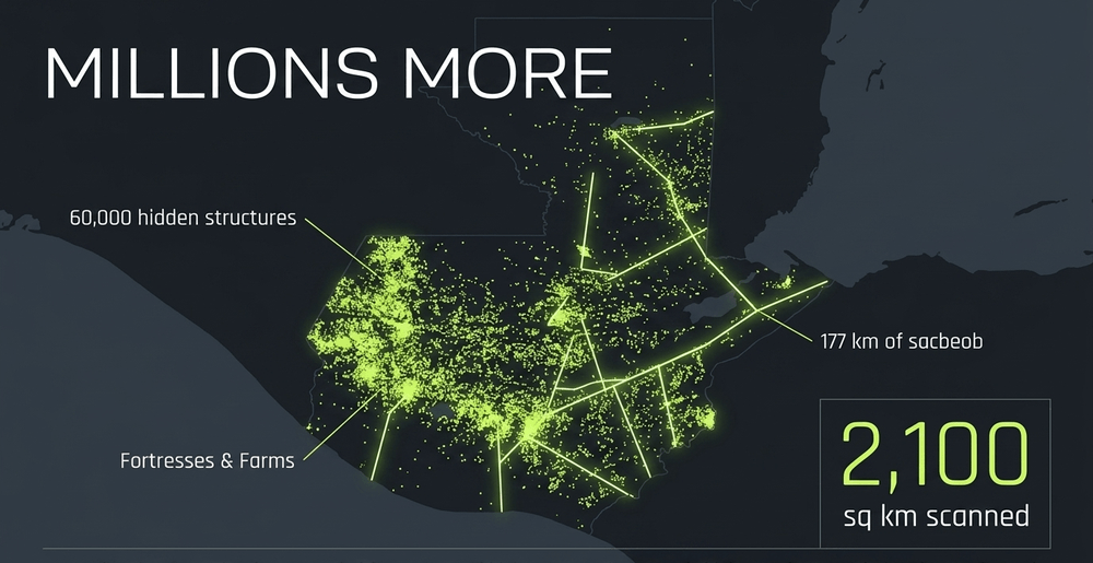
In the Mirador-Calakmul Karst Basin of northern Guatemala, LiDAR identified nearly 1,000 settlements dating to the Preclassic period (ca. 1000 BCE to 150 CE). These sites were connected by approximately 177 kilometers of elevated causeways. The presence of pyramids, ballcourts, and reservoirs across such a vast area suggests a highly organized society that modified its environment with a sophistication that rivals modern engineering.
Similar results transformed understanding at Caracol, Belize, where a 200-square-kilometer survey revealed a landscape almost entirely covered with agricultural terraces and urban settlements, effectively multiplying the known extent of the city many times over in a single LiDAR mission.
The pace of discovery continues even at well-known sites. In Mexico's Campeche region, a city named Ocomtún - meaning "stone column" in Yucatec Maya - was identified from LiDAR data in 2023. Nobody knew it existed. Located in the Balamkú Ecological Conservation Zone, the site sits in an area that represented a near-total blank on the archaeological map of the central Maya lowlands. Its monumental core covers more than 50 hectares and includes pyramids exceeding 15 meters in height, a ballcourt, cylindrical stone columns, and plazas arranged in patterns archaeologists are still working to understand. As lead archaeologist Ivan Šprajc noted, the area's impenetrability is precisely what kept it hidden from ground-based research for so long.
Angkor and the rethinking of tropical urbanism
Beyond the Americas, LiDAR has fundamentally changed the narrative of Southeast Asian history. A survey covering 370 square kilometers around Angkor, Cambodia, revealed that the urban footprint of the Khmer Empire was far more extensive than anyone had imagined. LiDAR showed that the temple of Angkor Wat was the center of a massive, dispersed low-density city that was home to an estimated 700,000 to 900,000 people at its height in the 13th century CE, making it one of the largest pre-modern urban agglomerations in the world. The Greater Angkor Region, when taken as a whole, covered an area of approximately 3,000 square kilometers - with dispersed occupation and cultivation extending across at least 1,000 square kilometers from the urban core alone.
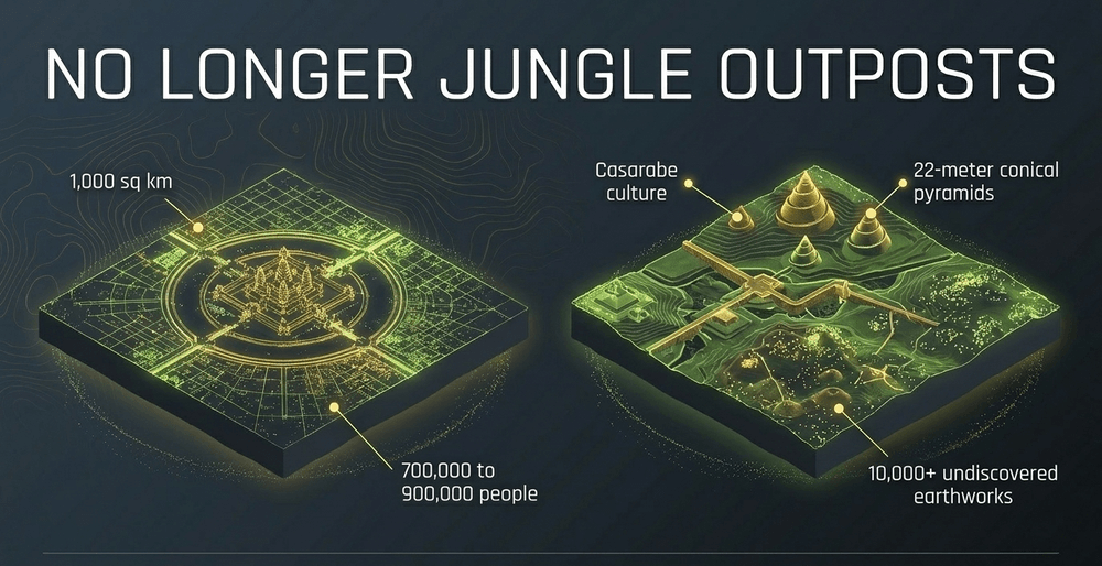
This data forced historians to reevaluate the concept of tropical urbanism, demonstrating that these civilizations were not jungle-bound outposts but massive, integrated urban systems. Evidence of a scale of human organization that ground-based survey alone could never have revealed.
Lost cities of the Amazon
Perhaps the most startling revelations have come from the Amazon rainforest, a place long assumed by some to be a "counterfeit paradise" incapable of supporting large-scale urbanism. A study published in the journal Nature revealed two remarkably large urban sites belonging to the Casarabe culture in the Llanos de Mojos savannah-forest mosaic of the Bolivian Amazon. The larger of the two primary centers covers 315 hectares and includes conical pyramids up to 22 meters tall. These sites are part of a dense, four-tiered settlement system connected by straight raised causeways and extensive water-management infrastructure. The known Casarabe culture area spans approximately 4,500 square kilometers.
The Casarabe findings were only part of a broader story. A separate study published in the journal Science in October 2023, using LiDAR surveys across the wider Amazon basin, discovered 24 previously unreported pre-Columbian earthworks and - by modeling their density across the region - estimated that between approximately 10,000 and 24,000 ancient earthworks likely remain undiscovered beneath the forest canopy. These discoveries prove that the Amazon was a managed landscape, home to sprawling urban networks long before the arrival of Europeans.
Expanding the map: recent discoveries worldwide
LiDAR's reach has extended far beyond the tropics in recent years, reshaping archaeological understanding across multiple continents.
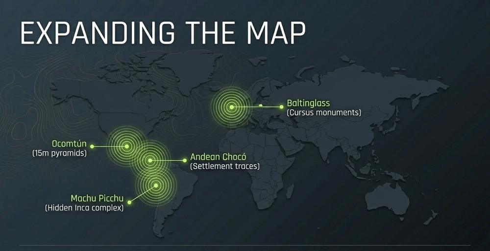
- In Peru, drone-mounted LiDAR surveys at the Chachabamba ceremonial complex within the Machu Picchu Archaeological Park revealed around a dozen previously unknown structures - including staff housing and stone-lined water channels - suggesting the Inca complex was far more extensive than the visible stone ruins imply. The discovery also reinforces a broader point about Inca engineering: mountain cities were not isolated monuments, but highly planned systems of hydrology, labor, and terrain management, much like the hidden design principles explored in Inside the secret engineering of Machu Picchu.
- In Ireland, a survey published in the journal Antiquity revealed hundreds of previously unrecorded monuments at Baltinglass in County Wicklow, including the largest cursus monument complex found in either Britain or Ireland.
- Across the wider Maya lowlands, follow-up surveys have continued to transform known sites. A Tulane University study used LiDAR data to identify 110,000 buildings across the central Maya lowlands of southern Mexico and northern Guatemala, with roughly 30% of those structures featuring masonry architecture including vaulted ceilings and arches - the most comprehensive wealth-and-status mapping ever attempted using the technology.
The pace of discovery is accelerating. As one archaeologist has put it: "There's a real sense of urgency around site mapping and site detection just because coastal erosion, wildfires, tsunamis - large-scale climate events - are impacting sites." LiDAR gives researchers the speed to document what might otherwise be lost.
Technical limitations and the need for ground truthing
Despite its power, LiDAR is not infallible. In areas with extremely thick foliage - such as dense bamboo groves - laser pulses may fail to reach the ground entirely, leaving blind spots in the data. Furthermore, LiDAR cannot penetrate solid surfaces. It cannot see through rock, thick concrete, or the soil itself. It can identify a mound that might be a pyramid, but it cannot see the pottery shards, jewelry, or skeletal remains buried within it.
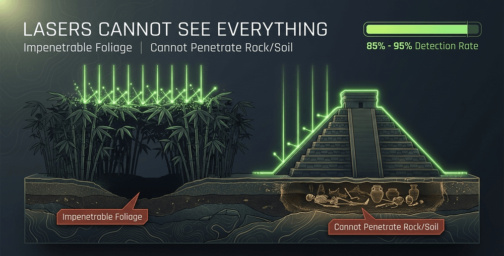
This brings us to the necessity of ground truthing. No matter how detailed the 3D model looks on a computer screen, an archaeologist must eventually put on their boots and walk the site. Ground verification is required to confirm that a digital feature is genuinely man-made and not a natural geological formation. Erosion, fallen trees, and animal activity can all create topographic patterns that mimic ancient ditches or walls. Without physical inspection, there is a real risk of misinterpreting digital data and drawing false conclusions about the scale and nature of a site.
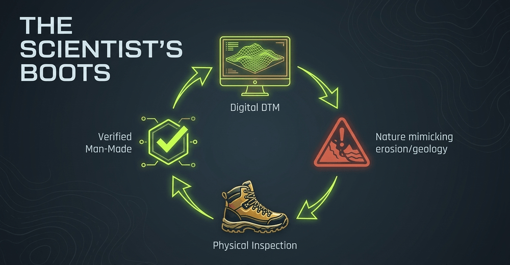
It is also worth noting that LiDAR detects an estimated 85 to 95 percent of artificial structures in favorable conditions - impressive, but not complete. The technology has raised questions faster than excavation teams can answer them, creating a growing backlog of sites requiring ground verification that may take decades to work through.
Digital colonialism and the ethics of aerial mapping
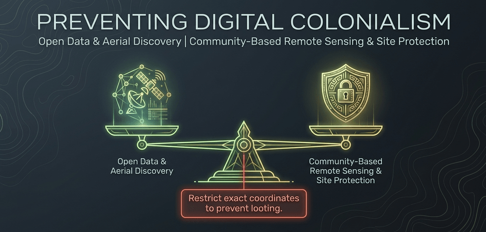
As LiDAR becomes the standard for archaeological exploration, it brings with it a set of complex ethical challenges. The most pressing is the concept of digital colonialism. For too long, Western researchers have used remote sensing to "discover" sites on Indigenous ancestral lands without the involvement or consent of the descendant communities. This practice can objectify Indigenous people and ignore the living knowledge and spiritual connections they maintain with these landscapes.
Researchers and institutions have increasingly called for a model of community-based remote sensing - one that involves sharing LiDAR results with local stakeholders before publication and allowing Indigenous perspectives to shape interpretation of the data. This approach is not just ethically sound; it often leads to better science. Indigenous communities frequently possess sophisticated knowledge of land management and historical geography that can explain features the LiDAR data reveals but the archaeologist might otherwise misunderstand.
There are also significant concerns around site protection. High-resolution LiDAR maps can act as a blueprint for looters. Publishing the exact coordinates of a previously unknown pyramid in a remote jungle puts that site at immediate risk. As a result, many archaeological organizations now restrict access to high-resolution datasets, sharing only lower-resolution versions with the public to protect the integrity of cultural heritage.
The next frontier: multispectral and spaceborne LiDAR
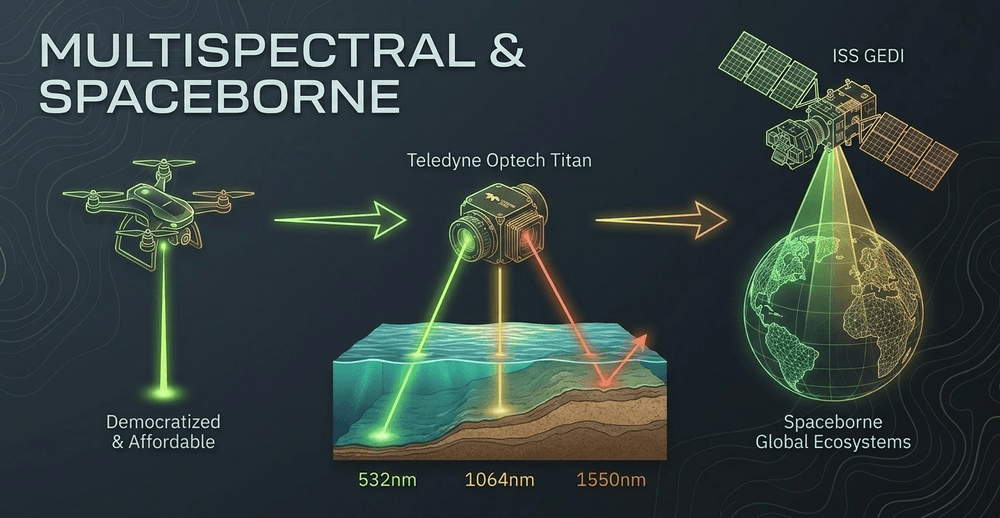
The technology continues to evolve rapidly. Multispectral LiDAR systems - such as the Teledyne Optech Titan, which fires three laser wavelengths simultaneously at 532 nm, 1064 nm, and 1550 nm - allow simultaneous mapping of both water depth and topography. This is vital for studying ancient coastal and riverine civilizations. By analyzing how different surfaces reflect different wavelengths, researchers can gain insights into soil moisture and vegetation health, which can indicate the presence of buried organic matter or ancient canals.
On a global scale, NASA's GEDI (Global Ecosystem Dynamics Investigation) instrument - a full-waveform LiDAR system installed on the International Space Station - is providing an unprecedented 3D view of the world's forests. While its primary mission is tracking carbon cycles and forest biomass, GEDI's data offers a macro-context for archaeologists studying how ancient human activity permanently altered the Earth's ecosystems. Researchers have already begun reanalyzing GEDI datasets to search for large-scale archaeological signatures invisible to conventional remote sensing.
Drone-mounted LiDAR is also democratizing the technology. Equipment that cost millions of dollars in 2010 now runs in the hundreds of thousands, making comprehensive mapping projects realistic for universities and smaller research organizations that could not previously afford airborne surveys.
We are moving toward a future where the entire planet's surface will be mapped in three dimensions - a living digital archive of human history accessible to researchers across the globe.
LiDAR and climate urgency: mapping before it is too late
One dimension of LiDAR archaeology that is gaining increasing urgency is the race against climate change. Coastal erosion, sea-level rise, wildfires, and extreme weather events are actively destroying archaeological sites at a pace that ground-based survey cannot match. LiDAR offers the possibility of creating a permanent digital record of sites that may be physically lost within decades.

This is particularly acute in low-lying tropical regions - precisely the areas where LiDAR has proven most transformative. Ancient Maya reservoirs, coastal Khmer settlements, and Amazonian earthworks are all vulnerable to the hydrological changes already being driven by a warming climate. The digital record LiDAR creates is not merely an academic convenience; it may ultimately represent the only surviving documentation of entire chapters of human civilization.
A new perspective on the human story
LiDAR has fundamentally transformed archaeology from a science of the shovel to a science of the landscape. It has allowed us to see the immense scale of human ambition and the profound impact our ancestors had on the natural world. From the hidden cities of the Maya to the urban sprawl of Angkor and the engineered landscapes of the Amazon, digital deforestation has revealed that our past was more crowded, more connected, and more complex than we ever dared to imagine.
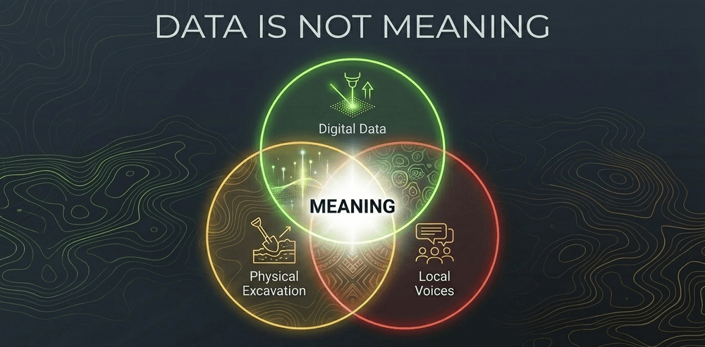
Yet as we continue to peel back the layers of the forest, humility is essential. The technology gives us data, but it does not give us meaning. That meaning is found in the collaboration between the digital model, the physical excavation, and the voices of those who still call these landscapes home. As we look toward the next decade of discovery, the challenge is to ensure that these lasers are used not just to map the past, but to honor the people who built it and the communities that protect it today.
Share now









Key takeaways
- LiDAR stands for Light Detection and Ranging - it maps terrain by firing millions of laser pulses from aircraft and measuring how long each pulse takes to return to the sensor
- The core formula: Distance = (Speed of Light × Time Elapsed) / 2 - the result is divided by two because each pulse travels down to the surface and back up to the sensor
- Modern airborne LiDAR achieves vertical accuracy within 4 to 6 inches and can detect features as small as 12 inches across
- A 13-square-kilometer area that would take a field team years to map on foot can now be covered in roughly 45 minutes of flight time
- The landmark 2018 PACUNAM LiDAR survey in Guatemala's Maya Biosphere Reserve identified over 61,000 previously unknown structures across more than 2,100 square kilometers - the largest such survey of the Maya lowlands at the time
- In the Mirador-Calakmul Karst Basin, LiDAR revealed nearly 1,000 ancient Maya settlements connected by approximately 177 km of elevated causeways, dating to the Preclassic period (ca. 1000 BCE-150 CE)
- A 2012 LiDAR survey at Angkor, Cambodia showed the Khmer city covered more than 1,000 square kilometers - a low-density urban complex that housed an estimated 700,000 to 900,000 people at its peak in the 13th century
- A 2022 Nature study used LiDAR to reveal Casarabe culture urban sites in the Bolivian Amazon, including one center covering 315 hectares with pyramids up to 22 meters tall
- A 2023 Science study estimated between 10,000 and 24,000 pre-Columbian earthworks remain hidden beneath the Amazon basin canopy
- The Teledyne Optech Titan multispectral LiDAR fires three simultaneous laser wavelengths (532 nm, 1064 nm, and 1550 nm), enabling both topographic mapping and shallow water-depth measurement in a single pass
- NASA's GEDI instrument on the International Space Station provides a global 3D view of forest structure, with secondary applications in large-scale archaeological landscape analysis
- LiDAR cannot see below the soil surface - it reveals mounds and earthworks but not the artifacts, burials, or architecture buried inside them
- Ground truthing remains essential: natural geological processes, fallen trees, and animal activity can create topographic patterns that closely mimic man-made structures
- Digital colonialism is an active ethical concern - Western researchers have frequently used LiDAR to "discover" sites on Indigenous lands without community consent or involvement
- High-resolution LiDAR datasets are increasingly restricted from public release to prevent the coordinates of newly found sites from being used by looters
- LiDAR equipment that cost millions in 2010 now runs in the hundreds of thousands, rapidly democratizing access for universities and smaller research institutions
- Climate change is creating urgency: coastal erosion, sea-level rise, and wildfires are actively destroying archaeological sites faster than ground-based teams can document them
Sources
- PACUNAM LiDAR Initiative - Canuto et al. (2018), Science https://www.science.org/doi/10.1126/science.aau0137
- LiDAR analyses in the Mirador-Calakmul Karst Basin - Hansen et al. (2022), Ancient Mesoamerica https://www.cambridge.org/core/journals/ancient-mesoamerica/article/lidar-analyses-in-the-contiguous-miradorcalakmul-karst-basin-guatemala/31075DFA8ADBAA5E7C7320CA6DB93E5E
- LiDAR reveals pre-Hispanic low-density urbanism in the Bolivian Amazon - Prümers et al. (2022), Nature https://www.nature.com/articles/s41586-022-04780-4
- More than 10,000 pre-Columbian earthworks remain hidden in the Amazon - Peripato et al. (2023), Science https://www.science.org/doi/10.1126/science.ade2541
- Uncovering archaeological landscapes at Angkor using LiDAR - Evans et al. (2013), PNAS https://www.pnas.org/doi/10.1073/pnas.1306539110
- Redefining Angkor: population study combining LiDAR and machine learning https://www.researchgate.net/publication/236597654_Redefining_Angkor_Structure_and_environment_in_the_largest_low_density_urban_complex_of_the_pre-industrial_world
- Airborne LiDAR, archaeology, and the ancient Maya landscape at Caracol, Belize - Chase et al. (2011), Journal of Archaeological Science https://www.caracol.org/wp-content/uploads/2016/05/ChaseEtAl2011.pdf
- Teledyne Optech Titan multispectral LiDAR - technical specifications https://www.businesswire.com/news/home/20180206006426/en/Teledyne-LiDAR-Reveals-Extensive-Maya-Civilization
- NASA GEDI (Global Ecosystem Dynamics Investigation) - instrument overview https://www.earthdata.nasa.gov/data/instruments/gedi-lidar
- Space LiDAR for archaeology: reanalyzing GEDI data for ancient Maya features https://www.sciencedirect.com/science/article/pii/S2352409X21000237
- YellowScan - How does LiDAR work? (technical explainer) https://www.yellowscan.com/knowledge/how-does-lidar-work/
- Smithsonian Magazine - Laser scans reveal 60,000 hidden Maya structures in Guatemala https://www.smithsonianmag.com/smart-news/laser-scans-reveal-60000-hidden-maya-structures-guatemala-180968030/
- Washington Post - New archaeology tools, LiDAR and space mapping discover lost cities (2024) https://www.washingtonpost.com/science/interactive/2024/archeology-discoveries-ai-lidar-lost-cities-ancient/
- Scientific American - Lasers reveal massive 650-square-mile Maya site beneath Guatemalan rainforest https://www.scientificamerican.com/article/lasers-reveal-massive-650-square-mile-maya-site-hidden-beneath-guatemalan-rainforest/
- Published 2026-06-10 15:37
- Modified 2026-06-11 18:04

-
Redaction