

-
 Redaction
The Nazca Lines explained: Myths and science
A comprehensive analysis of the Nazca geoglyphs, exploring their construction, ancient cultural purpose and the impact of modern AI on archaeological discovery.
Deep within the hyper-arid plains of southern Peru, a vast canvas of earth remains etched with the ambitions of a civilization that thrived two millennia ago. The Nazca Lines represent a singular intersection of engineering, art, and spirituality - recognized by UNESCO as a World Heritage Site since 1994 and studied continuously for nearly a century.
These enormous geoglyphs, carved into the floor of the Nazca Desert, span approximately 450 to 500 square kilometers of southern Peru. The scale of the project is staggering: over 800 straight lines, 300 geometric figures, and 70 intricate zoomorphic designs. From the massive 135-meter condor to the 93-meter hummingbird, the desert surface acts as a permanent record of the Nazca culture, which flourished between 500 BC and 500 AD. Some evidence suggests the earlier Paracas culture may have initiated this tradition as early as 400 BC, establishing a foundational aesthetic that their successors would expand upon for centuries.
How the Nazca Lines were built
The persistence of these lines across centuries is not the result of deep excavations, but rather a precise subtractive technique. The desert floor is covered in a layer of reddish-brown pebbles coated in iron oxide. By removing these dark stones, the Nazca people exposed the lighter, yellowish-grey earth underneath - creating a high-contrast visual effect that endures to this day.
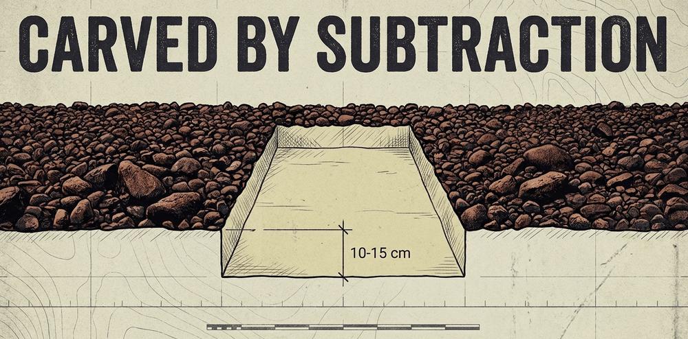
Most lines are surprisingly shallow, ranging from just 10 to 15 centimeters in depth, yet they have resisted the ravages of time due to the unique environmental conditions of the region. The Nazca Desert is one of the driest places on Earth, characterized by minimal rainfall and a near-total absence of ground-level wind. This stability prevents erosion and allows the exposed subsoil to harden into a natural protective crust.
Researchers have debunked the notion that aerial surveillance was necessary to achieve such geometric precision. Archaeological findings - including wooden stakes at the termini of various lines - suggest the use of fundamental surveying tools. By employing ropes and stakes to create a grid system, ancient engineers could scale small sketches into massive geoglyphs. Experimental reconstructions demonstrate that a small, organized team could replicate even the most complex figures within a matter of days. This evidence highlights the remarkable technical proficiency of the Nazca civilization without any need for speculative technologies.
The most iconic geoglyph figures
Among the hundreds of designs etched into the desert plateau, several have captured the world's imagination more than others. The most celebrated include:
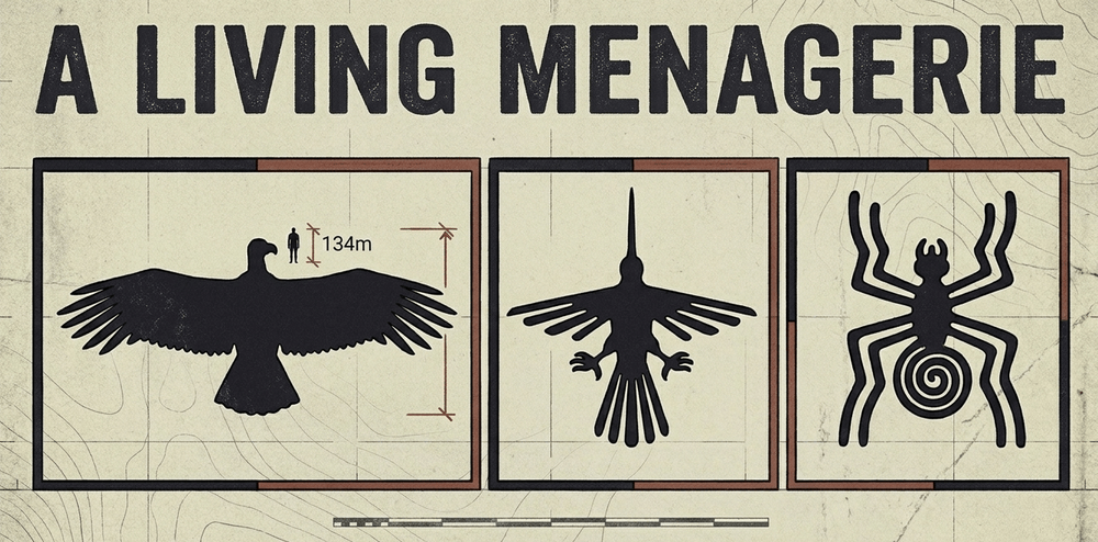
- The Condor - At approximately 135 meters in length, this bird of prey is one of the largest and most precisely drawn figures on the plateau.
- The Hummingbird - Measuring 93 meters, its flowing lines suggest an extraordinary understanding of natural proportion.
- The Spider - A remarkably detailed 46-meter figure, possibly linked to water divination rituals due to the spider's association with rainfall in Andean cosmology.
- The Monkey - Distinguished by its spiraling tail, this figure spans roughly 110 meters in length and is only accessible from a single natural vantage point in the surrounding hills.
- The "Astronaut" - A 30-meter figure popularly misidentified as an extraterrestrial, now interpreted by archaeologists as a depiction of an owl-man or shamanic figure consistent with known Andean iconographic traditions.
The so-called "Astronaut" became a centerpiece of extraterrestrial theories popularized in Erich von Däniken's Chariots of the Gods. Academic consensus firmly rejects these claims. The figure's form is entirely consistent with the spiritual imagery documented across Andean pottery, textiles, and ceremonial objects of the same period.
A gallery of the Nazca Lines
The astronaut
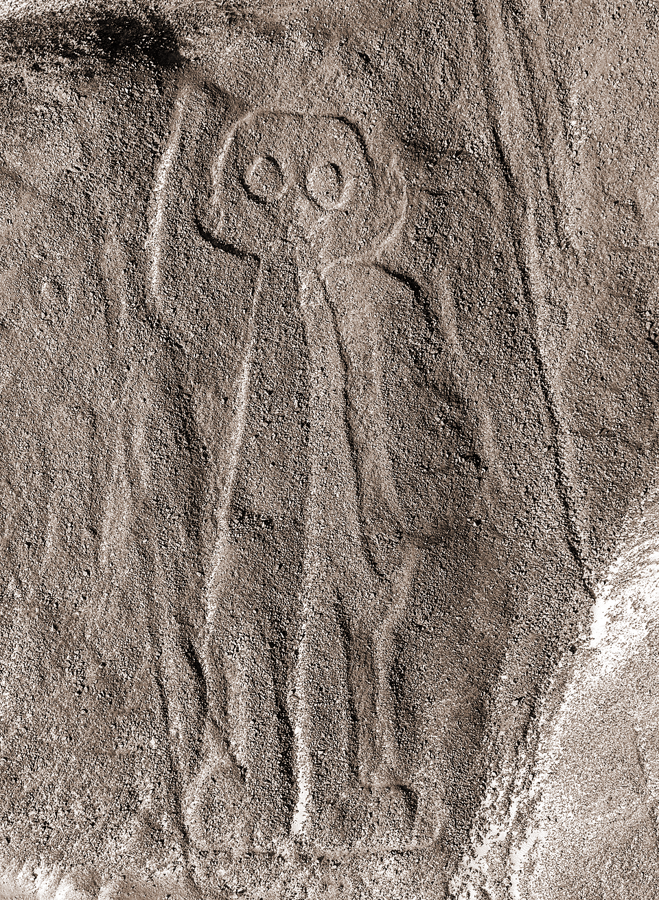
One of the most debated figures on the plateau, this 30-meter humanoid figure is carved into a steep hillside - making it one of the few geoglyphs visible from ground level. Popular culture has long misread its bulbous head and outstretched arm as evidence of alien contact. Archaeologists read it differently: the rounded cranium echoes the elongated skulls practiced as a status symbol by Paracas elites, and the raised hand is a recurring gesture in shamanic iconography across the Andes. It is, in all probability, a depiction of an owl-man - a figure bridging the human and spirit worlds.
The condor
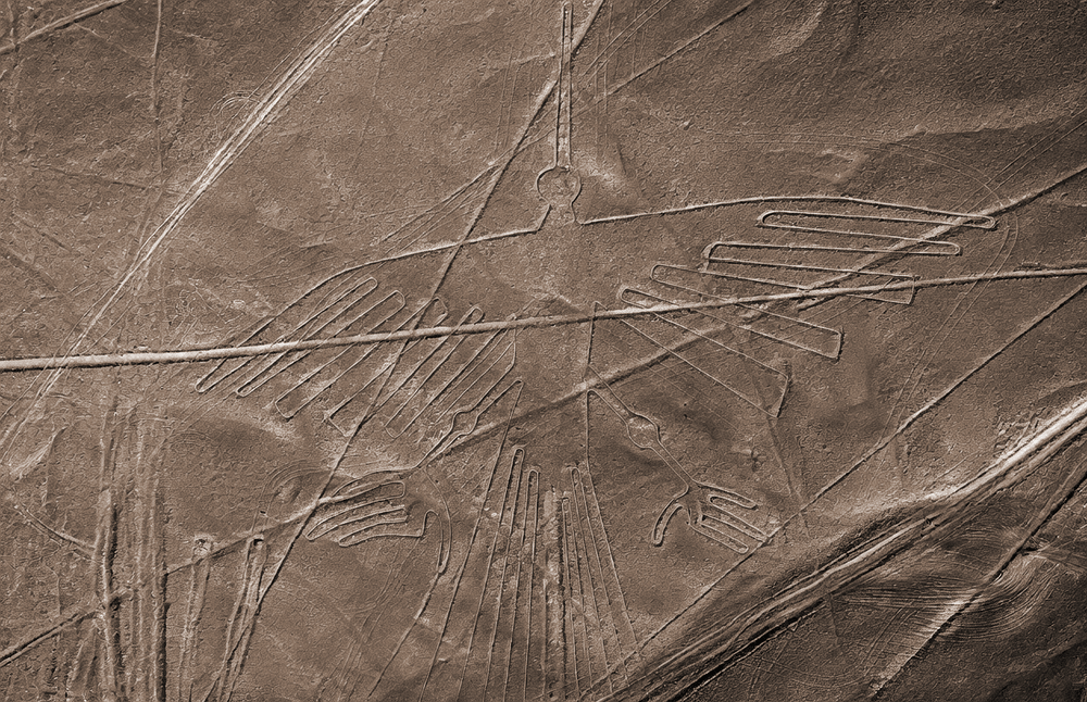
Stretching approximately 135 meters from wingtip to tail, the condor is one of the most expansive figurative geoglyphs on the Nazca plateau. The Andean condor (Vultur gryphus) held profound symbolic significance across pre-Columbian cultures as a messenger between the terrestrial and divine realms. The figure's wingspan is rendered with a precision that speaks to careful planning and systematic scaling - the work of engineers who understood proportion even without the aerial view we rely on today.
The dog
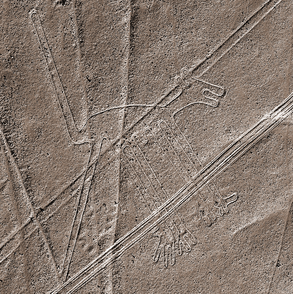
Less frequently discussed than the condor or monkey, the dog geoglyph is nonetheless a striking example of the Nazca culture's ability to capture the essence of a living creature in a handful of continuous lines. Dogs appear frequently in Andean burial contexts, often interred alongside humans, suggesting a close ceremonial relationship. This figure may reflect beliefs about companionship in the afterlife or the role of dogs as guides between worlds.
The flower
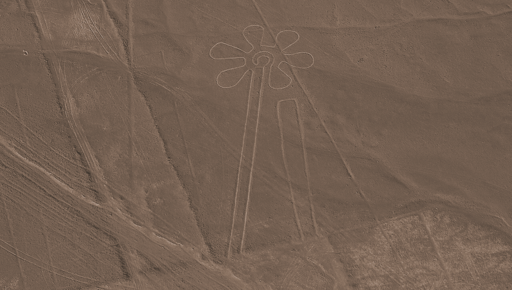
Among the flora depicted on the plateau, the flower figure is one of the most geometrically refined. Its radiating petals and central core demonstrate the same command of symmetry that characterizes the animal figures. Plant geoglyphs are less common than zoomorphic ones, but their presence underscores the agricultural underpinning of Nazca cosmology - a culture profoundly preoccupied with growth, rainfall, and the fertility of the land.
The hands
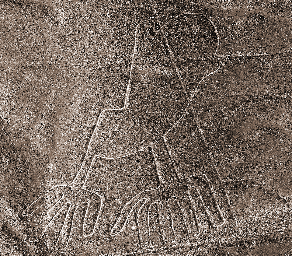
The hands figure - depicting a human figure with what appears to be four fingers on one hand and five on the other - has prompted considerable speculation. Some researchers interpret the uneven fingers as a mark of social distinction or priestly rank; others suggest deliberate asymmetry as a symbolic rather than anatomical choice. Whatever the interpretation, this geoglyph is a rare instance of the human body rendered with anatomical focus, standing apart from the more abstract shamanic figures elsewhere on the plateau.
The heron
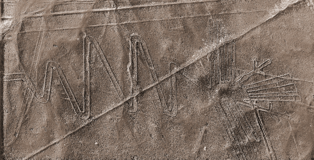
The heron - sometimes classified as a crane or egret - is a long-necked wading bird whose seasonal movements along river valleys made it a natural marker of water cycles in the Andean world. Its elongated form traces a graceful arc across the desert floor. That a water-associated bird was chosen for monumental depiction in one of the driest environments on Earth is itself a statement: the Nazca people were acutely aware of their dependence on water, and embedded that awareness in the landscape itself.
The hummingbird
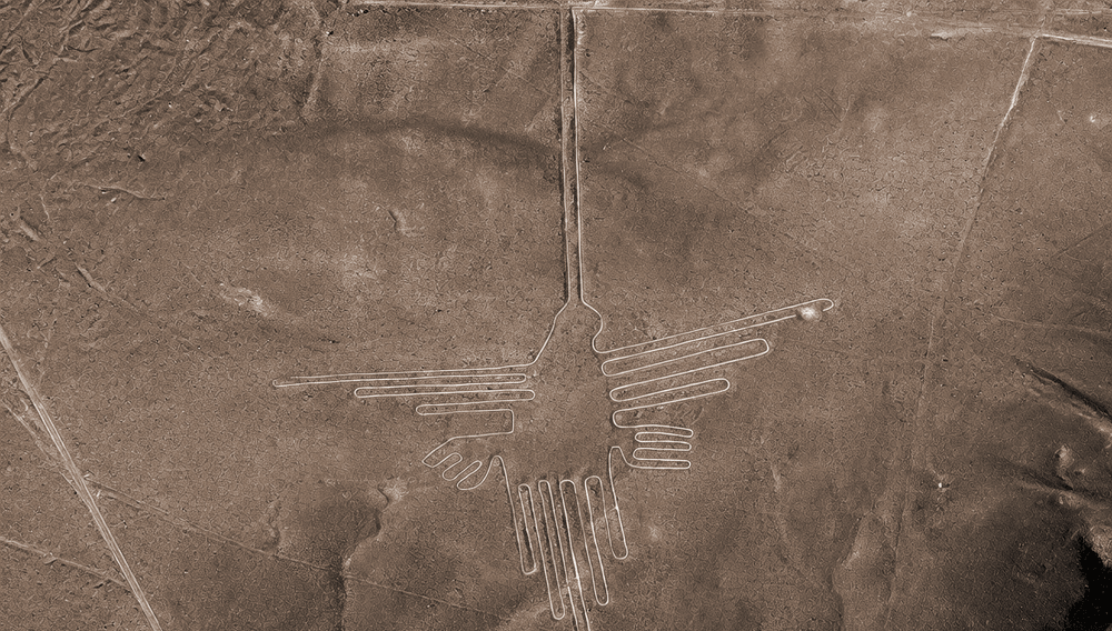
At 93 meters, the hummingbird is among the most celebrated of all the Nazca figures - and one of the most technically impressive. Its long, needle-like beak, swept wings, and forked tail are rendered in a single flowing line that never crosses itself. Hummingbirds in Andean tradition are associated with resurrection and the passage of the soul; they appear frequently in funerary ceramics. The precision of this figure, visible only in its entirety from altitude, is a remarkable demonstration of the Nazca people's ability to think and plan at a scale that transcended the individual.
The monkey
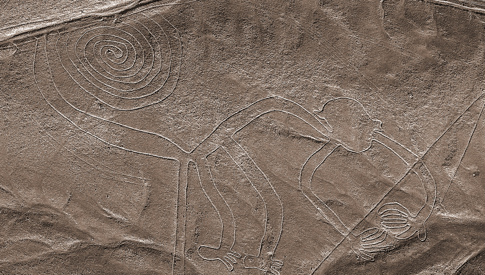
The monkey geoglyph - approximately 110 meters in length - is one of the most immediately recognizable figures on the plateau, defined by its elaborate spiraling tail. Monkeys are not native to the coastal desert; they inhabit the Amazon Basin far to the east. Their appearance here is therefore a deliberate cultural import, linking the Nazca world to the jungle regions beyond the Andes. In many Andean traditions, the monkey symbolizes water from the east - a fitting figure for a civilization obsessed with rainfall and river flow.
The parrot
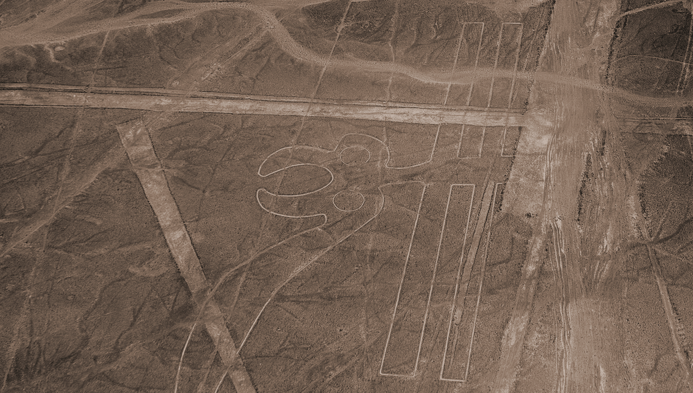
Like the monkey, the parrot is a tropical species that would have been known to the Nazca people through long-distance trade networks rather than direct experience. Its vivid plumage made it a prestige commodity across pre-Columbian South America. The geoglyph's outstretched wings and curved beak are instantly recognizable even at altitude. The parrot's inclusion alongside jungle animals like the monkey suggests a deliberate cosmographic map - a desert landscape encoding the full breadth of the known world.
The pelican
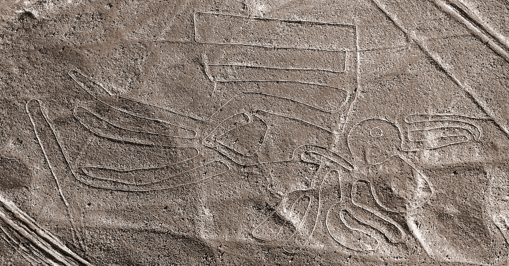
The pelican figure is among the longest bird geoglyphs on the plateau, with some measurements placing it at close to 285 meters from beak to tail - making it one of the largest single figurative geoglyphs at Nazca. The pelican is a coastal bird well known to the Nazca people, who lived within reach of the Pacific. Its enormous throat pouch, used to catch fish, may have carried symbolic resonances related to abundance, the sea, and the provision of food. The sheer scale of this figure suggests it held considerable ceremonial importance.
The spider
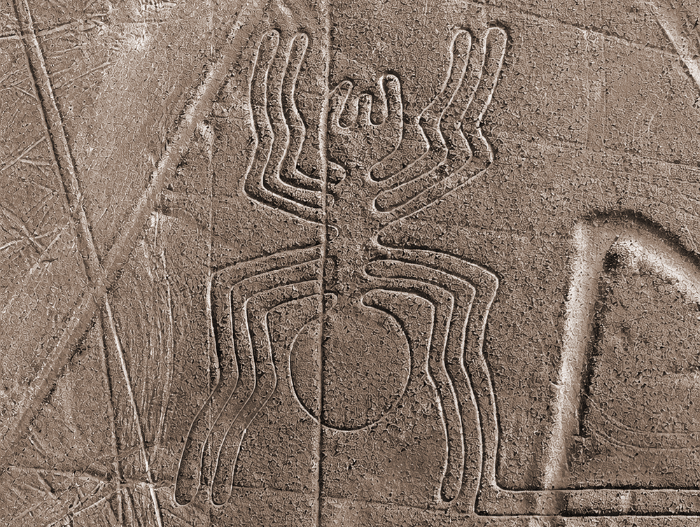
At 46 meters, the spider is one of the most precisely detailed figures on the plateau. Certain spider species in the Andes are considered indicators of rain - their behaviour patterns reportedly change before rainfall - making the spider a natural symbol of water prophecy in an arid landscape. Some researchers have also noted that the spider's body may encode astronomical data relating to Orion, though this interpretation remains contested. What is not contested is the extraordinary draughtsmanship: legs, body segments, and reproductive organs are all rendered with scientific accuracy.
The tree
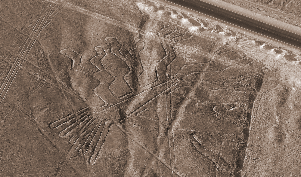
The tree geoglyph is one of the more abstract figures on the plateau - its branching form recognizable as a stylized plant rather than a specific species. In the arid Nazca world, trees and vegetation were inherently associated with water, life, and sustenance. As a geoglyph, the tree may have functioned as a marker of fertility or a symbolic anchor within a landscape organized around the logic of growth and rainfall. Its relatively modest scale, compared to the condor or pelican, suggests it may have been designed for close-range viewing along a trail.
The whale
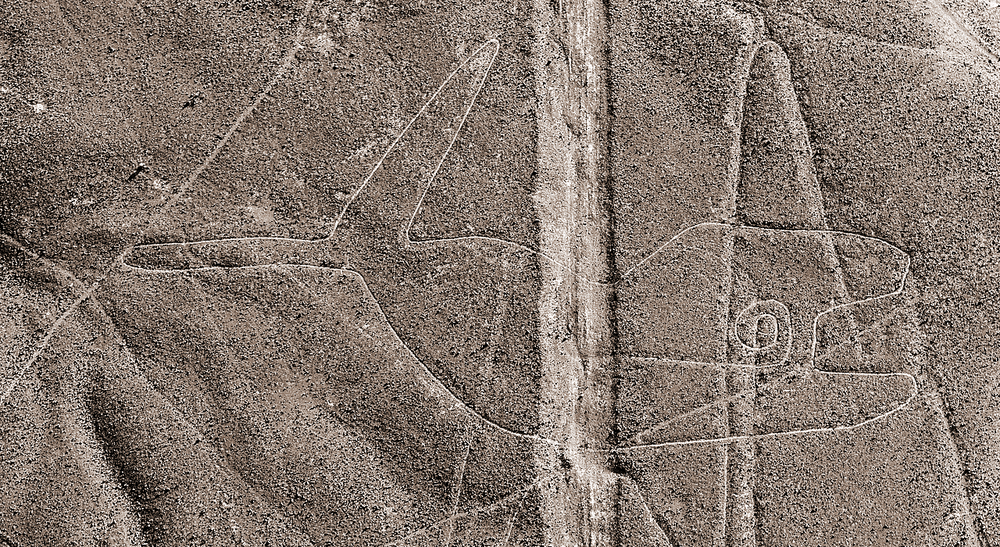
The whale geoglyph - sometimes identified as a killer whale or orca - is one of the most mythologically loaded figures at Nazca. In Andean iconography, the orca appears repeatedly on painted ceramics as a fearsome agent of sacrifice: a creature associated with the sea, with death, and with the appeasement of powerful natural forces. The original known whale geoglyph measures approximately 65 meters. The newly AI-discovered killer whale geoglyph, a 22-meter relief-type figure holding a knife, directly mirrors sacrificial orca imagery found on Nazca pottery - one of the most striking connections yet made between the desert floor and the culture's surviving material record.
Deciphering the purpose of the geoglyphs
The objective behind such a colossal investment of labor remains the subject of rigorous academic inquiry. Because the Nazca culture left no written records, researchers must rely on archaeological context and spatial analysis to interpret the lines. Several competing theories provide a framework for understanding these desert markings.
Astronomical and cosmological alignments
One of the earliest and most persistent theories is that the lines functioned as a terrestrial calendar. Scholars such as historian Paul Kosok and mathematician Maria Reiche dedicated decades to the study of celestial alignments. They proposed that specific lines pointed toward the rising or setting positions of the sun, moon, and stars during solstices and equinoxes. According to this view, the geoglyphs served as a tool for tracking seasonal changes - vital for an agricultural society dependent on precise planting cycles.
However, this theory faced a significant challenge when astronomer Gerald Hawkins conducted a computerized analysis of the site. His findings indicated that the lines, as a whole, could not be explained primarily as astronomical markers - a conclusion later reinforced in a joint study with archaeoastronomer Anthony Aveni. Cosmology, scholars now largely agree, was perhaps only a secondary function of the site rather than its primary purpose.
Water, ritual and sacred landscape
In a region where water is the most precious resource, the relationship between the geoglyphs and hydrology is a focal point of modern research. Many geoglyphs appear to be connected to the flow of water - either marking the path of subterranean aquifers or pointing toward mountains where rainfall originates.
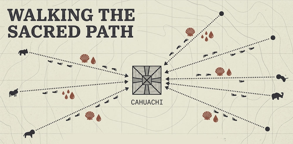
The presence of platforms at the end of many figures, coupled with fragments of thorny oyster shells (Spondylus), points strongly toward ritualistic activity. Spondylus shells were used throughout the Andes in ceremonies to invoke rain and fertility. This suggests the lines may have been sacred pathways for processions, where the act of walking the figure itself served as a physical prayer for water in an unforgiving landscape. Unlike modern roads intended for transport, these paths were designed for ritual movement - weaving the practical and the spiritual together in ways that resist easy categorization.
Two types of geoglyph, two scales of experience
Recent research has revealed a fundamental distinction that reshapes how we understand the site. The Nazca landscape was designed to operate at two entirely different scales simultaneously.
Large, line-type geoglyphs - the famous animal and bird figures stretching up to several hundred meters - cluster near Cahuachi and other ceremonial centers. These were built for the collective: massive spiritual landmarks visible from elevated ground, designed to draw pilgrimage groups toward a shared spiritual center. Small, relief-type geoglyphs, by contrast, sit along ancient winding trails and average around 10 meters in length. Positioned within viewing distance of a single traveler, they depict intimate human motifs - humanoids, domesticated camelids, scenes of ritual sacrifice. These were designed for individual experience.
The distinction suggests not decorative impulse but deliberate spatial design: a landscape choreographed to guide both individual and communal religious experience across the same terrain.
Cahuachi: the ceremonial heartland
The lines do not exist in isolation. Many of the larger animal figures cluster near the start and end points of ancient pilgrimage routes leading to Cahuachi, a major ceremonial center located approximately 28 kilometers northwest of the city of Nazca. Excavations at Cahuachi - conducted over several decades by archaeologist Giuseppe Orefici - have revealed a vast complex of adobe pyramids, plazas, and ritual offerings that suggest the site functioned as a hub for pan-regional religious gatherings.
The spatial relationship between the geoglyphs and Cahuachi strongly supports the theory that the lines served as ritual plazas rather than astronomical instruments or mere artworks. Pilgrims traveling to the site may have walked specific figures as part of ceremonial observance, transforming the desert floor into a living, participatory landscape.

The integration of artificial intelligence in archaeology
While the Nazca Lines have been studied for nearly a century, the pace of discovery has accelerated dramatically in recent years. This shift is driven by the application of artificial intelligence to remote sensing data. Traditional methods of identifying geoglyphs relied on the human eye to parse satellite imagery and aerial photographs - a process both time-consuming and prone to overlooking smaller, weathered designs. Between 1940 and 2000, surveys added figurative geoglyphs at roughly just 1.5 per year.
The impact of AI-assisted surveys
A collaboration between Yamagata University's Institute of Nasca and IBM Research utilized machine learning algorithms to process high-resolution aerial imagery, including drone-captured photographs. Their AI model was trained to recognize the subtle geometric signatures of geoglyphs that are often invisible to traditional observers. A field survey conducted between September 2022 and February 2023 confirmed 303 previously unknown figures - including humanoids, domesticated animals, and complex scenes involving decapitated heads and killer whales.
According to research published in the Proceedings of the National Academy of Sciences (PNAS), the AI system achieved a 16-fold increase in the rate of geoglyph discovery compared to manual survey methods, allowing archaeologists to concentrate their fieldwork on AI-verified targets rather than scanning the entire plateau manually.
A subsequent round of AI-supported field surveys conducted across 2023 and 2024 confirmed an additional 248 geoglyphs - announced by Professor Masato Sakai of Yamagata University at Expo 2025 Osaka. Of these, 160 are figurative geoglyphs depicting animals, humans, and symbolic scenes. This brought the total number of documented figurative designs to 893, of which 781 have been identified through the AI-assisted program.
Geoglyphs as narrative: a new theory
The imagery and spatial arrangement revealed by AI has prompted a significant shift in scholarly thinking. Rather than treating each geoglyph as a standalone design, researchers now propose that groups of figures arranged along specific paths functioned as sequential narratives - a visual language conveying shared beliefs and social memory.
One path features continuous imagery of priests holding human heads, another a progression of llamas. A third depicts birds of prey in sequence. This thematic clustering suggests, according to Sakai's team, that the ancient Nazca did not simply decorate the landscape but authored it - using the desert floor as a medium for telling communal stories about faith, sacrifice, and the forces that governed their world.
Cultural implications of the new findings
The imagery revealed by AI also provides deeper insight into the more confrontational aspects of Nazca mythology. A geoglyph depicting a 22-meter killer whale holding a knife is among the most notable recent finds. Sakai's team has noted that this image directly mirrors sacrifice-related motifs found on Nazca pottery, where orcas are frequently associated with human sacrifice and the appeasement of nature spirits.
The high frequency of severed head imagery across newly found geoglyphs suggests the lines were deeply integrated into a belief system linking life, death, fertility, and the volatile forces of nature. This discovery has reshaped scholarly understanding of Nazca religion, revealing a worldview that was simultaneously agricultural, cosmological, and sacrificial - and far more complex than the famous "mysterious lines" narrative implies.

Who was Maria Reiche - and why does she still matter?
No figure looms larger in the modern study of the Nazca Lines than Maria Reiche (1903-1998), a German mathematician and archaeologist who dedicated more than five decades of her life to studying and protecting the geoglyphs. She arrived in Peru in 1932, met Paul Kosok in the early 1940s, and remained on the Nazca plateau for the rest of her working life - living in a house beside the lines, measuring them by hand, and sweeping them clean with a broom.
Reiche championed the astronomical calendar theory with missionary conviction, arguing that the lines mapped solstices, equinoxes, and stellar events. While later researchers have tempered this interpretation, her meticulous surveys produced the most detailed early maps of the site and established archaeology's basic vocabulary for describing the figures. She also campaigned tirelessly for the site's protection at a time when vehicles and development threatened to destroy it permanently.
Her legacy is recognized in the name of the Nazca airport - the Aeródromo María Reiche Neuman - and in the Maria Reiche Museum near the site. She is, in many respects, the reason the lines survived long enough to be studied by AI.
The extraterrestrial myth: where it came from and why it persists
The idea that the Nazca Lines were built by, or for, extraterrestrials was not a fringe belief for much of the twentieth century - it was a bestseller. Erich von Däniken's Chariots of the Gods, published in 1968, argued that the lines were runways or navigational markers for alien spacecraft, and that figures like the "Astronaut" were portraits of non-human visitors. The book sold tens of millions of copies and generated a genre of popular speculation that continues to circulate online today.
The academic response has been uniform and unambiguous. The engineering required to build the lines is well within human capability - experimental archaeology has demonstrated this repeatedly. The "Astronaut" figure is consistent with known Andean shamanic imagery. The geometric precision of the lines does not require aerial guidance: it requires ropes, stakes, and organized labor, all of which are documented in the archaeological record.
The persistence of the extraterrestrial theory says less about the Nazca Lines than it does about the human tendency to underestimate ancient civilizations - and the commercial appetite for mystery that a more nuanced explanation cannot easily satisfy.

Preserving a fragile legacy
The expansion of the catalog to 893 geoglyphs underscores the extraordinary complexity of the Nazca landscape. It is now understood that the desert was not a static museum but a dynamic ritual environment that evolved over nearly a millennium. The challenge lies in protecting these sites from encroaching pressures including illegal mining operations, agricultural expansion, and the steady growth of tourism.
The same arid conditions that preserved the lines for 2,000 years also make them incredibly fragile. A single footprint or vehicle track can remain visible for decades. The dangers of human encroachment were made vividly clear when environmental activists caused permanent damage to the area near the hummingbird figure during an unauthorized publicity stunt - a stark reminder that even well-intentioned human presence can be irreversible.
The Peruvian Ministry of Culture, alongside UNESCO and Yamagata University, has since developed integrated monitoring systems combining drone surveillance, AI-assisted satellite analysis, and on-the-ground patrols to detect and respond to threats in real time.
Visiting the Nazca Lines
For travelers, the geoglyphs are most commonly viewed from small aircraft departing from Nazca's Aeródromo María Reiche Neuman or the nearby city of Ica. Several viewing towers along the Pan-American Highway offer limited ground-level perspectives of select figures. The closest major city is Nazca itself, approximately 400 kilometers south of Lima.
Visitors are strongly advised to book flights exclusively with operators licensed by Peru's Ministry of Transport. The best viewing conditions are typically in the morning, before afternoon winds and atmospheric haze reduce clarity. Ground access around the geoglyphs is tightly controlled; entering the protected zone on foot or by vehicle without authorization is both illegal and causes lasting damage.
What the lines continue to teach us
As researchers continue to refine the digital map of the Nazca Desert, the focus has shifted from mere identification to holistic interpretation and preservation. The use of AI has not only multiplied the number of known geoglyphs but has provided a more nuanced understanding of how the Nazca people organized and experienced their world.
"The Nazca Line geoglyphs are not independent artworks, but through various combinations and arrangements, they seem to play a role as media for conveying faith and memory."
- Professor Masato Sakai, Yamagata University
Each newly identified figure is not merely an addition to a catalog - it is a fragment of a lost cosmology, slowly being reassembled across centuries of silence. The ongoing collaboration between Yamagata University, IBM Research, and Peruvian authorities ensures that as technology advances, the voices of the ancient Nazca people continue to be heard.
These lines were more than art. They were a sophisticated language etched into the earth - a communal effort to navigate the precarious balance between human survival and the volatile forces of nature.
Share now









Key takeaways
- The Nazca Lines were created by the Nazca and Paracas cultures between approximately 500 BC and 500 AD; the Paracas tradition may have begun as early as 400 BC.
- Designated a UNESCO World Heritage Site in 1994, the geoglyphs cover approximately 450-500 square kilometers of the Peruvian desert plateau.
- The site encompasses over 800 straight lines, 300 geometric figures, and 70 zoomorphic designs - including a ~135-meter condor, a 93-meter hummingbird, and a pelican stretching close to 285 meters.
- Construction involved removing reddish-brown iron oxide pebbles to expose lighter yellowish-grey subsoil at depths of just 10-15 centimeters.
- The extreme aridity of the Nazca Desert - one of the driest environments on Earth - is the primary reason the lines have survived for two millennia.
- The lines were built using simple surveying tools: ropes, stakes, and grid-scaling techniques. No aerial technology was required or used.
- German mathematician Maria Reiche (1903-1998) dedicated over five decades to measuring, mapping, and protecting the site, and is credited with much of the foundational research.
- The astronomical calendar theory, championed by Reiche and Paul Kosok, was significantly challenged by astronomer Gerald Hawkins and archaeoastronomer Anthony Aveni, whose analyses found no systematic celestial alignment across the lines as a whole.
- Current scholarly consensus favors sacred processional routes linked to water ritual and the ceremonial center of Cahuachi as the primary function of the lines.
- Before AI-assisted surveys, it had taken nearly a century to catalog approximately 430 figurative geoglyphs, at an average rate of just 1.5 new figures per year between 1940 and 2000.
- A collaboration between Yamagata University's Institute of Nasca and IBM Research used deep-learning algorithms to identify and confirm 303 new geoglyphs in a single six-month field survey (September 2022 - February 2023), published in the Proceedings of the National Academy of Sciences (PNAS).
- The AI system achieved a 16-fold increase in the discovery rate compared to previous manual survey methods.
- A subsequent round of AI-supported surveys in 2023-2024 confirmed a further 248 geoglyphs, announced by Professor Masato Sakai at Expo 2025 Osaka in July 2025.
- The total number of documented figurative geoglyphs now stands at 893, of which 781 were identified through the AI-assisted program.
- AI analysis has revealed two distinct geoglyph types: large line-type figures (averaging ~90 meters) clustered near ceremonial centers for communal ritual, and small relief-type figures (~10 meters) placed along walking trails for individual experience.
- Newly identified figures are typically arranged as sequential narratives along ancient paths, suggesting the Nazca people used the desert floor as a medium for communal storytelling and shared memory.
- A recently confirmed 22-meter killer whale holding a knife directly mirrors sacrifice-related motifs found on Nazca pottery, linking the geoglyphs to a complex belief system involving fertility, death, and natural forces.
- The lines are extremely fragile: a single footprint or vehicle track can remain visible for decades.
- The Peruvian Ministry of Culture, UNESCO, and Yamagata University now operate integrated monitoring systems using drone surveillance and AI-assisted satellite analysis to protect the site in real time.
Sources
- Wikipedia https://en.wikipedia.org/wiki/Nazca_lines
- Britannica https://www.britannica.com/place/Nazca-Lines
- Yamagata University https://www.yamagata-u.ac.jp/en/information/info/20240924/
- National Geographic https://www.nationalgeographic.com/history/article/nasca-glyphs
- The Guardian https://www.theguardian.com/world/2024/sep/26/nazca-lines-peru-new-geoglyphs
- PNAS (Proceedings of the National Academy of Sciences) https://www.pnas.org/doi/10.1073/pnas.2407652121
- UNESCO World Heritage https://whc.unesco.org/en/list/700
- The Japan Times https://www.japantimes.co.jp/news/2025/07/29/japan/nazca-lines-geoglyphs/
- The Art Newspaper https://www.theartnewspaper.com/2025/08/14/248-nazca-lines-discovered-artificial-intelligence-peru
- Live Science https://www.livescience.com/archaeology/knife-wielding-orca-and-alien-looking-figures-among-300-nazca-lines-discovered-in-groundbreaking-ai-study
- Published 2026-05-27 21:04
- Modified 2026-06-11 18:06
