
-
112
Views
-
0
Comments
-
1
Like
-
Bookmark

-
 Redaction
New LiDAR data uncovers the hidden secrets of Machu Picchu
New LiDAR data reveals Machu Picchu is a subterranean machine with 60% of its structure underground. Inca engineers used seismic design to survive for centuries.
The hidden foundation
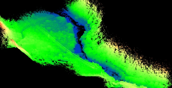
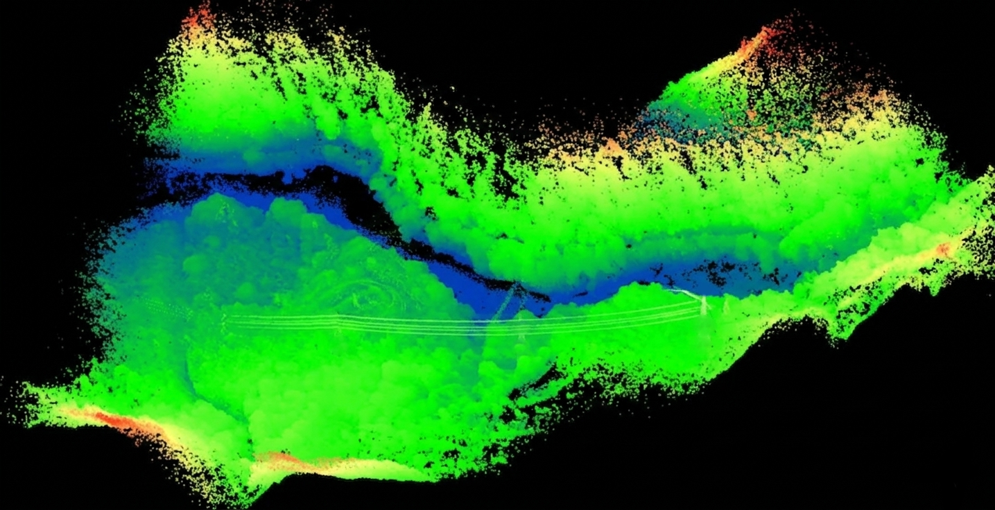
Recent investigations conducted between late 2024 and April 2026 have shifted the archaeological focus at Machu Picchu from its visible granite peaks to the dark soil beneath them. Data derived from drone-mounted LiDAR and ground-penetrating radar (GPR) indicates that the primary architectural triumph of the site is not what stands above ground, but the vast subterranean machine supporting it. Engineers now estimate that 50% to 60% of the total construction effort was dedicated to underground infrastructure.
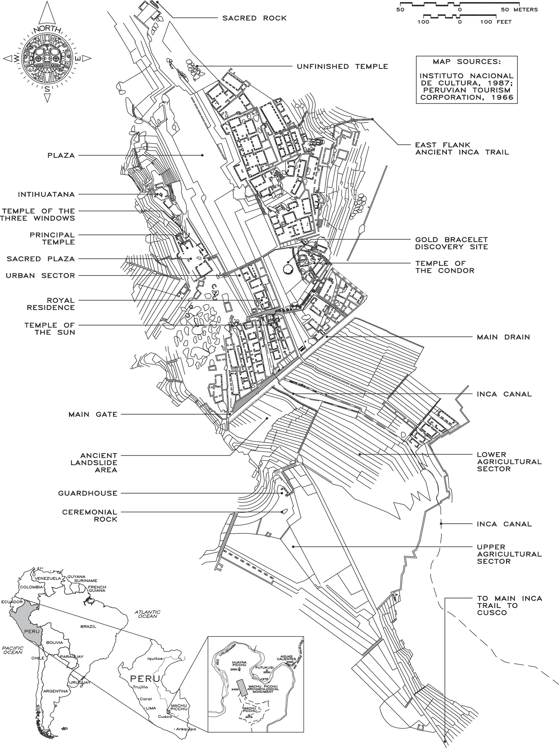
This hidden network functions as a kinetic shock absorber. Analysis from early 2026 confirms that the foundation consists of layered deposits of large stones, gravel, and sand. This configuration serves a dual purpose: it stabilizes the steep Andean slopes against the constant threat of landslides and allows high-volume rainwater to infiltrate the ground rapidly. By managing water flow internally, the Inca engineers prevented the surface erosion that would have otherwise claimed the citadel centuries ago.
Seismic architecture and the logic of the fault
The site selection for Machu Picchu was not merely aesthetic. Research led by Rualdo Menegat, updated through 2025, suggests the city sits precisely atop intersecting geological fault lines. Faults, extending up to 110 miles, provided the builders with a ready supply of pre-fractured granite. This geological shortcut reduced the energy required for quarrying and shaping the massive blocks used in the city's refined walls.
Inca masonry techniques reflect a sophisticated understanding of kinetic energy. The use of ashlar masonry - fitting stones with millimetric precision without the use of mortar - created flexible joints. During seismic events, these stones are capable of moving independently, a process described by researchers as a structural "dance," before settling back into their original positions. According to experimental data, the gaps between these stones are often less than 2 mm, a margin thinner than a standard credit card.
Complementing this flexibility is the pervasive use of trapezoidal geometry. Doors, windows, and niches are wider at the base, a design that distributes weight more effectively and ensures that structural pressure is directed inward during lateral movements. Data suggest a major magnitude 6.5 earthquake around 1450 AD may have been the catalyst for these advanced engineering standards, pushing the Inca away from simpler cellular architecture toward these earthquake-resistant forms.
The drainage network as a hydraulic computer
Rainfall in the Andes is often torrential, yet the drainage system at Machu Picchu remains functional after five centuries. Between 2024 and 2026, hydraulic analysis revealed that the 700 agricultural terraces are high-performance drainage structures. Each terrace follows a strict engineering protocol: a foundation of stones exceeding 1,000 lbs, followed by layers of smaller gravel, sand, and finally topsoil.
System is capable of handling water volumes equivalent to a small river. A 750-meter-long stone canal delivered clean water from local springs to 16 interconnected fountains. While the system was designed for a steady flow of 25 liters per minute, it possessed the capacity to accommodate up to 100 liters per minute during peak events. Engineers have identified two stone safety valves designed to redirect excess stormwater during flooding, protecting the city's residential core from inundation.
Logistical mysteries and material transport
The transport of 60,000 tons of stone for the terraces alone remains a subject of intense technical study. Blocks weighing over 50 tons were moved across vertical terrain without the benefit of wheeled vehicles or pulleys. Evidence found along precisely graded Inca roads suggests the use of wooden rollers, bronze-tipped levers, and inclined ramps.
Recent high-resolution 3D scanning shows that the precision of Inca stonework extends deep into the interfaces where stones meet, rather than being a surface-level refinement. X-ray analysis of the refined walls confirms that the internal geometry of the blocks was as carefully managed as the external faces. This level of precision was achieved using a combination of stone hammers, wooden wedges, and abrasive sand slurries, allowing the builders to exploit natural fracture lines with surgical accuracy.
New frontiers in the jungle canopy
The application of LiDAR technology in 2024 and 2025 has effectively rewritten the map of the site. Over 12 previously unknown structures have been identified beneath the dense forest canopy. These buildings appear to be simpler in design, likely serving as residences for the labor force or lower-level administrative staff. These discoveries indicate that the footprint of Machu Picchu was significantly larger and more densely populated than previously recorded.
Furthermore, DNA analysis of 34 individuals recovered from the site provides a new demographic perspective. The data indicates that approximately one-third of the residents possessed Amazonian ancestry. This suggests that Machu Picchu served as a diverse imperial hub, drawing populations from the distant reaches of the empire rather than being an isolated mountain retreat for a monolithic ethnic group.
Lessons from the Lost City
The engineering of Machu Picchu serves as a clinical reminder that longevity is a product of what remains unseen. In a modern era characterized by rapid surface-level construction and fragile infrastructure, the Inca's decision to invest 60% of their labor into the foundation and drainage systems provides a blueprint for resilience. Their ability to integrate a city into a volatile geological environment, rather than fighting against it, reflects a level of foresight that current urban planners are only beginning to replicate with sustainable drainage systems and base-isolation technology. The stones of Machu Picchu still stand because they were designed to move; a paradox of stability through flexibility that modern society has yet to fully master.
Share now


Key takeaways
- Roughly 50-60% of the construction at Machu Picchu is located underground, serving as a seismic shock absorber.
- Recent LiDAR scans from 2024-2025 uncovered 12 new structures hidden by jungle growth within 60 feet of the main tourist zones.
- The agricultural terraces utilize a multi-layered drainage system composed of large stones, gravel, and sand to prevent erosion.
- Structures were intentionally built on intersecting geological fault lines to utilize pre-fractured granite blocks.
- DNA analysis of individuals buried at the site reveals that nearly a third possessed Amazonian ancestry, indicating a diverse imperial population.
Sources
- Menegat, R. (2019). Geological Society of America presentation on Machu Picchu fault lines.
- Wright, K. R. (1997). Machu Picchu: Ancient Hydraulic Engineering. Journal of Hydraulic Engineering.
- Salazar, L. et al. (2023). DNA analysis of Machu Picchu occupants. Science Advances.
- Cusco-Pata Research Project (2018). Study on the 1450 AD earthquake at Machu Picchu.
- LiDAR surveys conducted 2024–2025 by Peruvian and international archaeological teams.
