
-
58
Views
-
0
Comments
-
1
Like
-
Bookmark

-
 Redaction
Hōkūlea and the science of Polynesian wayfinding
An analysis of traditional Polynesian wayfinding techniques and the ongoing Moananuiākea voyage of the Hōkūleʻa as it reaches its 50th anniversary.
The double-hulled voyaging canoe Hōkūleʻa is currently undergoing maintenance in dry dock in Auckland, Aotearoa (New Zealand). This period of reflection and preparation forms part of the larger Moananuiākea voyage-a multi-year circumnavigation of the Pacific that began in 2023 from Juneau, Alaska. The voyage is expected to cover approximately 43,000 nautical miles and visit 36 countries and archipelagoes, nearly 100 Indigenous territories, and hundreds of ports before its conclusion.
This maritime effort is not merely a physical journey across the largest ocean on Earth; it is a living demonstration of a sophisticated cognitive technology that nearly vanished from human memory. As the Polynesian Voyaging Society (PVS) marks the 50th anniversary of Hōkūleʻa's maiden voyage to Tahiti in 1976, the focus remains on the precise mathematical, astronomical, and environmental systems that enabled ancient Polynesian navigators to master the Pacific.
The architecture of the star compass
Traditional Polynesian wayfinding is based on a mental sidereal compass that divides the horizon into 32 distinct “houses,” each spanning 11.25 degrees (360° ÷ 32). System allows navigators to orient the vessel according to the rising and setting points of key stars, the Sun, and the Moon.
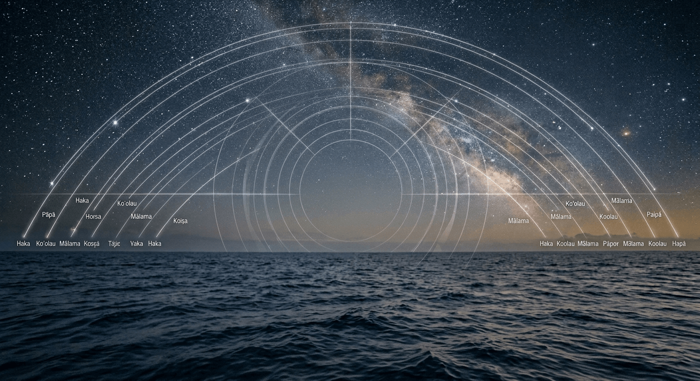
Unlike Western navigation, which depends on external instruments for numerical headings, the Polynesian navigator internalizes the celestial sphere. Stars rise in the east and set in the west along parallel paths within their respective hemispheres. A star rising in a particular “house” in the eastern sky will set in the corresponding house in the western sky. Symmetry creates a reliable mental grid for maintaining course over thousands of miles.
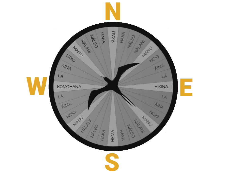
To determine latitude, wayfinders use stellar altitude measurements, often calibrated by the width of fingers held at arm's length against the horizon. By identifying the altitude of “home stars” associated with specific islands, navigators can “sail down the latitude” to reach a target destination with remarkable precision. The modern Hawaiian star compass was developed by master navigator Nainoa Thompson, building on knowledge shared by Mau Piailug from Satawal in the Caroline Islands.
The Etak system and spatial relativity
One of the most sophisticated elements of Pacific navigation is the Etak system, primarily preserved in the Caroline Islands and taught to Hawaiian navigators by Mau Piailug. In Etak, the navigator imagines the canoe as stationary while the islands and reference points appear to move beneath the star houses.
An invisible reference island (an “out-of-sight” landmark) is mentally selected. As the voyage progresses, this reference point is visualized shifting from one star house to another. By tracking these mental movements, the navigator estimates distance traveled and distance remaining. This form of dead reckoning integrates estimates of speed derived from wave patterns, wind pressure, and the canoe's motion against the hull.
Environmental indicators and multi-sensory data
While celestial bodies provide the primary framework, environmental cues serve as vital secondary references-especially when clouds obscure the stars. Navigators monitor consistent ocean swells, which are long-period waves generated by distant storms and distinct from local wind-driven waves. These swells can maintain direction for days, offering a stable directional reference.
Additional biological and atmospheric indicators include:
- Seabird behavior: Species such as the white tern and noddy tern often fly toward land in the evening and out to sea in the morning, serving as living compasses.
- Cloud formations: Stationary clouds, specific color tints on cloud undersides, or lens-shaped clouds can signal land or lagoons beyond the horizon.
- Water characteristics: Changes in water color, temperature, floating vegetation, or patterns of drifting debris indicate proximity to land.
Multi-sensory techniques form a comprehensive, resilient navigation system refined over centuries.
The 50th anniversary and cultural perpetuation
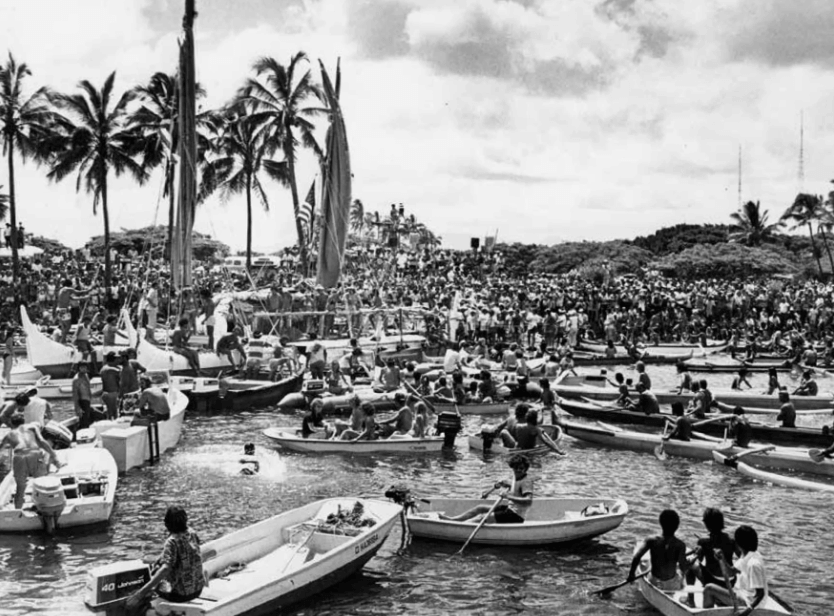
In 2026, the Polynesian Voyaging Society and partners are commemorating the 50th anniversary of Hōkūleʻa's historic 1976 maiden voyage. On May 1, 1976, the canoe departed Honolua Bay, Maui, under the guidance of master navigator Mau Piailug. After more than 30 days at sea, it made landfall in Tahiti on June 4, 1976, where over 17,000 people welcomed the crew in Papeʻete Harbor. The voyage proved that traditional non-instrument navigation could successfully cross vast ocean distances.
In Honolulu, the anniversary is being marked by the world-premiere full performance of composer Michael-Thomas Foumai's choral symphony Raise Hawaiki at the Neal S. Blaisdell Concert Hall on April 19, 2026, presented by the Hawaiʻi Symphony Orchestra with the Oʻahu Choral Society and narration.
Since the early 1980s, and especially under the leadership of Nainoa Thompson since the 1990s, the Polynesian Voyaging Society has trained new generations of navigators. The current Moananuiākea voyage serves as a mobile classroom and diplomatic vessel, promoting cultural exchange, youth leadership, and the principle of mālama-caring for the ecological and cultural integrity of “island Earth.”
Evidence of ancient Polynesian reach
The effectiveness of these navigation systems is supported by scientific findings. Genetic research published in 2020 (Ioannidis et al.) provides strong evidence of contact between Polynesian and Indigenous South American populations around 1200 CE-approximately 800 years ago. This pre-Columbian interaction is further corroborated by the presence of the sweet potato (Ipomoea batatas), a crop native to the Americas, in Polynesia centuries before European arrival, along with supporting linguistic and archaeological data.
These findings affirm that the 32-house star compass, Etak logic, and environmental wayfinding techniques were robust enough to enable trans-oceanic voyages across the world's largest ocean, establishing Polynesian navigators as among history's most accomplished maritime explorers.
Share now


Key takeaways
- Hōkūleʻa (with sister vessel Hikianalia) is in Auckland, Aotearoa New Zealand, for maintenance as part of the Moananuiākea voyage (2023–2027/2028), a ~43,000-nautical-mile circumnavigation.
- 2026 marks the 50th anniversary of the 1976 maiden voyage from Hawaiʻi to Tahiti.
- Traditional wayfinding relies on a 32-house mental star compass and the Etak system.
- Genetic evidence confirms contact between Polynesians and South American Indigenous peoples ~800 years ago (ca. 1200 CE).
- Navigator training has been led by Nainoa Thompson and the Polynesian Voyaging Society for decades, with formal perpetuation efforts intensifying since the 1980s–1990s.
Sources
- hokulea.comhttps://hokulea.com/moananuiakea/
- wikipedia.orghttps://en.wikipedia.org/wiki/H%C5%8Dk%C5%ABle%CA%BBa
- youtube.comhttps://www.youtube.com/watch?v=0n5GwS8F63Y
- hokulea.comhttps://hokulea.com/polynesian-wayfinding/
